If you are looking for a really fun winter hike near Canmore, check out the McGillivray Canyon Trail. This unique Kananaskis winter hike follows the path of a McGillivray Creek riverbed into a narrow slot canyon between Pigeon Peak and Mount McGillivray.
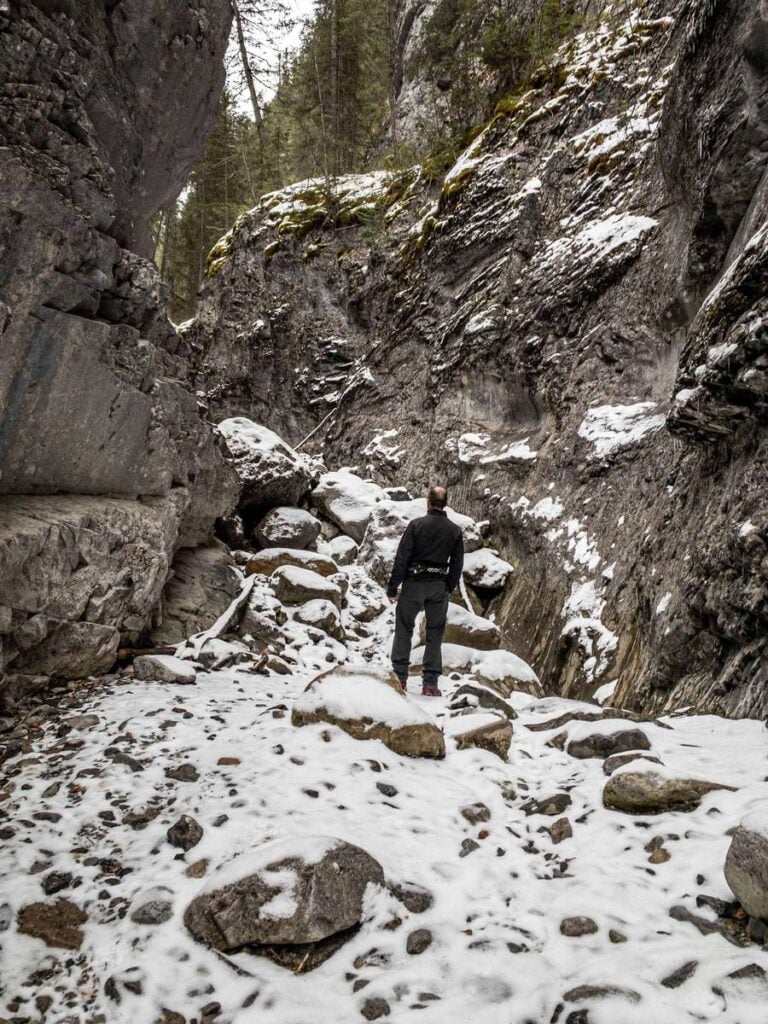
After an enjoyable forest walk along the TransCanada Trail and then up the valley wall of McGillivray Canyon, you’ll descend to the valley floor. Here, the McGillivray Creek and Canyon trail leads you deeper into the canyon, beneath beautiful and humbling towering canyon walls.
Your final destination is the incredible McGillivray Canyon chockstone – a massive boulder stuck in-between two very tight slot canyon walls. It’s one of the most interesting photography opportunities in all of Kananaskis Country!

This post contains compensated links.
McGillivray Canyon Hike Highlights
After a quick walk from the parking lot, you soon find yourself walking westbound on the TransCanada Trail. You’re only on the TransCanada Trail for approximately 200m or so, but I always enjoy the feeling of being on a hiking trail which goes from coast-to-coast in Canada. It’s the longest hiking trail in world – pretty cool!

The McGillivray Canyon trailhead is an unmarked left-hand turn off the TransCanada Trail into the forest. It’s a pleasant walk through the forest for another 300m until you arrive at the base of the McGillivray slot canyon. Look for a purple ribbon tied to a tree to alert you to the trail into the canyon.

At the 700 m mark of the McGillivray Canyon trail, you’ll arrive at a trail junction. The trails to the right lead into the mouth of the McGillivray Creek riverbed. This is where you used to begin the obstacle course up the McGillivray creek slot canyon, but as of March 2021, Alberta Parks has removed all the ropes and ladders, making this choice of trail impossible.
Not to worry, there is a beautiful bypass trail around the impassible lower McGillivray slot canyon which delivers you to the upper slot canyon! Rather than take the trails to the right, continue hiking straight to stay on the bypass trail.

The McGillivray Canyon trail starts ascending the north-east wall of the canyon wall, with the McGillivray Creek riverbed down below on your right. As the hiking trail winds its way up through a beautiful forest, it can get a little steep in spots.
If you hike McGillivray Canyon in winter, we recommend having traction devices for your winter hiking boots. We love our Kahtoola microspikes for outstanding traction while winter hiking in Kananaskis.

Before long, the McGillivray Canyon trail begins to lead you further away from the bottom of the slot canyon. At the 1.0 km mark, you’ll stumble upon a large teepee in the forest, made from fallen tree trunks and branches. There’s something magical about teepees that kids can’t resist. If your kids are physically capable, this makes for a fun kid-friendly Kananaskis hike.
Beyond the McGillivray Canyon teepee, the terrain becomes quite visually interesting with lots of cool small cliffs and boulders scattered around the hillside. Keep your eyes open for mountain views on your right hand side.
The closest mountain, looming directly overhead, is Pigeon Peak (2,394 m), while you may also get occasional glimpses of Canmore’s famous Three Sisters (2,940 m) from behind.

At the 1.5 km mark, the McGillivray Creek and Canyon trail starts to descend back to the canyon floor. The descent is short, and sometimes pretty steep, so try to use nearby trees for extra support to prevent a slip going down the hill. Again, microspikes are perfect for this type of winter hiking terrain.

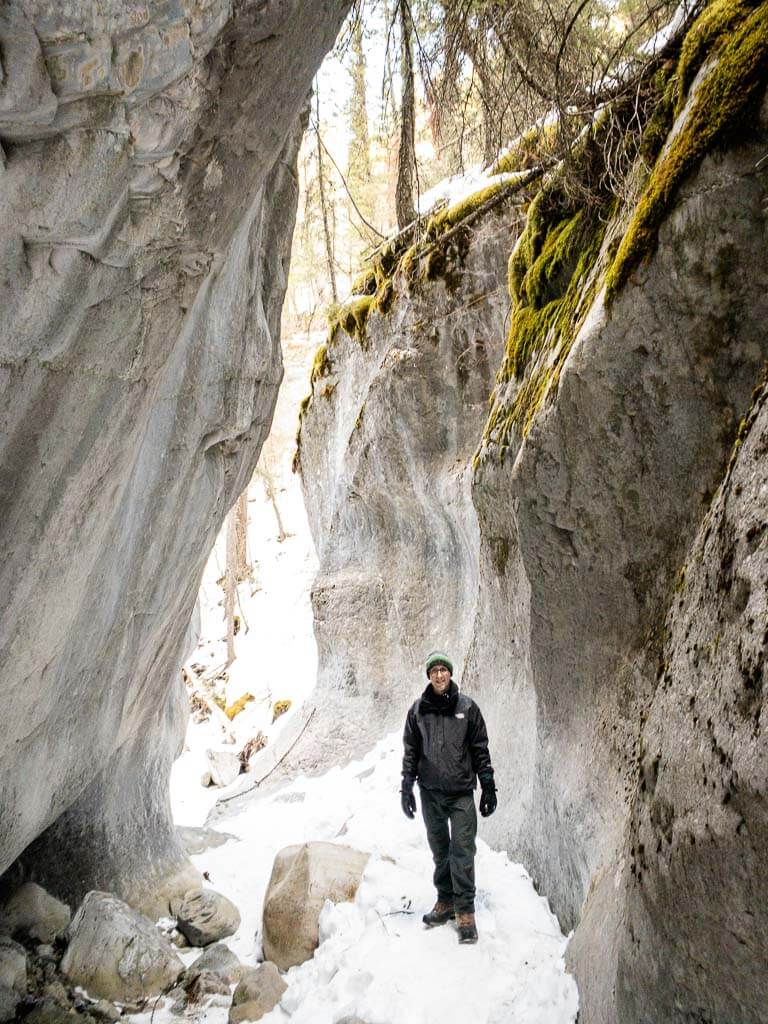
The descent is only 200 m long, and before long you are standing on the floor of the McGillivray Creek slot canyon. I love walking through slot canyons!
The McGillivray Canyon is much longer and better formed than the popular one at nearby Jura Creek Trail. The raw power of nature which has carved this path through solid stone over thousands of years never ceases to amaze me.

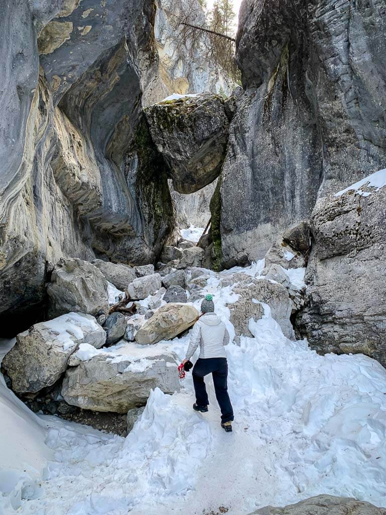
The canyon walls have been carved into magnificent shapes and the canyon floor is littered with massive boulders, dropped there by the power of McGillivray Creek. If the rocks and boulders haven’t yet been covered by a thick layer of snow they will slow your pace quite a bit as you find your way through them.
It’s a bit challenging, but certainly manageable for most winter hikers. In the heart of winter, they should be fully covered, making your winter trek up the slot canyon much easier.

After another 600 m or so of walking through the towering canyon walls of the beautiful McGillivray Canyon, you’ll arrive at your destination. The most famous part of the McGillivray Canyon Trail is the massive chockstone stuck between the slot canyon walls.
This massive boulder is equal parts beautiful and impressive and makes the effort to hike there completely worthwhile. There are ways to go behind and climb up on top of the McGillivray Canyon chockstone, but the risk didn’t seem worth it to us…

McGillivray Creek Canyon Trail Location
The McGillivray Canyon Trail isn’t the easiest Kananaskis hike to find. Here’s how to find the McGillivray Canyon Trail:
The McGillivray Canyon parking lot is an unmarked lot on the south side of the TransCanada Highway, just moments west of Lac des Arcs.

Access to the McGillivray Canyon parking lot is only available if you are traveling eastbound on Highway 1. Once you see the large tower from the Lafarge plant straight ahead, slow down and look on your right for a gravel road into the trees.
If you are driving from Calgary to McGillivray Canyon, you’ll need to drive west for a few minutes past the parking lot and turn around at Dead Man’s Flats.
Here is a Google Street View shot travelling eastbound on the TransCanada Highway. The McGillivray Canyon parking lot is the gravel road on the right.
Once you find the unmarked parking lot, the trailhead is easy to find; it heads south away from the highway into the forest.
As McGillivray Canyon is in Kananaskis Country, you will need a Kananaskis Conservation Pass to park here.

McGillivray Canyon parking lot location
McGillivray Canyon trailhead location
McGillivray Canyon Trail Stats
How Long is the McGillivray Creek and Canyon Hike?
The McGillivray Canyon hike is a pretty short Kananaskis hike, clocking in at roughly 4.3 km long (2.15km one-way). Your GPS may show the trail as longer, but that is likely because the tall canyon walls make it hard for your watch or phone GPS to get an accurate reading.

How Steep is the McGillivray Canyon Trail?
The total elevation gain you’ll encounter along the McGillivray Canyon Trail is approximately 200m. There are a few short, steep sections on the bypass trail around the lower McGillivray Creek slot canyon, but outside of that the incline of the hike to the McGillivray Canyon chockstone is quite gentle the whole way.

How Hard is the McGillivray Creek and Canyon Hiking Trail?
The McGillivray Creek and Canyon trail is short and not very steep, so we classify this as a short and easy Kananaskis winter hike.
There are a few elements to the McGillivray Canyon hike which may be difficult for some. There are a few short, but steep sections on the slot canyon bypass trail – in the winter these could be treacherous. If hikers wear proper traction devices, these sections shouldn’t pose much of a problem.

The final leg through the slot canyon to the McGillivray Creek chockstone has many medium and large boulders on the canyon floor. When the snow is deep, it’s no problem as they will be buried.
If the snow isn’t deep, then the snow and ice on top of these large rocks will force you to step more carefully and require you to plan your route through. Again, this section should be doable for most Kananaskis winter hikers, but may pose a challenge for some.
We rate the McGillivray Canyon Trail as “easy”, but be aware there are some who would rate this winter hike as ‘moderate’.

How Long Does It Take to Hike McGillivray Canyon?
It should take a typical adult roughly 90 minutes to complete the full round-trip distance of this unique Kananaskis winter hike.
McGillivray Canyon Trail Map
The McGillivray Creek & Canyon hiking trail is not easy to find or follow. The hiking trail begins heading south into the forest from the parking lot. After 200m you’ll arrive at a T-intersection for the TransCanada Trail.
Turn right at the T-intersection and walk for another 200m or so. There will be an unmarked trail heading left into the forest. Making things more challenging is the presence of multiple left-hand turns into the forest. In the winter, it only takes one person making an incorrect trail in the snow to throw everyone off.

Once you leave the TransCanada Trail, you are now officially on the McGillivray Canyon Trail. You’ll enjoy an easy 300m hike through the forest, before you reach the lower McGillivray Creek slot canyon bypass trail.
Do yourself a favor and download the “McGillivray Creek and Canyon Trail” map on the AllTrails app. We used it and found it invaluable for finding the proper left-hand turn into the forest. It was also very useful helping us find the location of the lower slot canyon bypass trail.
For most Kananaskis hikes, we describe AllTrails as a ‘nice to have’, but the McGillivray Canyon trail is confusing enough that we highly recommend you have it.
Being so close to Canmore and Dead Man’s Flats, you should have weak cell service near the highway, but it will be spotty at best after this point. It’s a good idea to download the McGillivray Canyon trail map onto your phone ahead of time just in case.
A recent App of the Year winner, AllTrails is also one of the best apps for visiting Banff! Enjoy map downloads and many more premium features with a 7-day free trial of AllTrails+!
Hiking McGillivray Canyon Trail with Kids
If you are looking for a fun, kid-friendly winter hike in Kananaskis, besides Troll Falls, why not give the McGillivray Canyon trail a try?
The McGillivray Creek and Canyon trail is a short and easy Kananaskis winter hike which has lots of fun elements for kids. The first being the large teepee on the lower slot canyon bypass trail. Be prepared to spend some time here as kids universally love playing in teepees.

Another magical element of this Kananaskis winter hike which kids will love is the final leg through the upper slot canyon. Again, there’s just something special about narrow, tall canyons that kids just seem to love. They’ll be amazed at the massive boulder stuck between the narrow canyon walls when you reach the end of the trail.
If you hike the McGillivray Creek and Canyon trail with your kids in winter, make sure they have traction devices on. Our kids use High Stream Gear ice cleats, which are well made and similar in style to the Kahtoola microspikes we love so much.

If you are looking for a longer Kananaskis winter hike and want to see a little Cold War history, you could always tack on the Heart Creek bunker trail to the end of the McGillivray Canyon trail. This interesting kid-friendly hike features a Cold War bunker dug deep into the mountain which is great fun to explore. You can access it from the McGillivray Creek Canyon parking lot, but you turn east on the TransCanada Trail instead of west.
If you are looking for another kid-friendly Kananaskis slot canyon hike, Jura Creek Trail is a great option. It’s also an especially good back-up if the Grotto Canyon ice walk parking lot is overflowing (as is typical).

Where to Stop for Lunch or a Break
There are no picnic tables or benches in the McGillivray Canyon parking lot or anywhere along the trail, but that doesn’t mean you can’t have a picnic lunch or snack.

The best place to stop for lunch on this fun Kananaskis winter hike is at the end of the McGillivray Canyon trail. There’s a bunch of large boulders where you can sit and look back at the amazing McGillivray chockstone and the towering canyon walls around it.
If you have room in your day bag, a winter picnic blanket is a nice touch. It allows you to sit on a cold & snowy rock without getting your butt too cold.
McGillivray Canyon Hiking Safety Tips
Kananaskis Wildlife Safety
In the dead of winter, the bears around McGillivray Creek Canyon should be hibernating (be careful in early winter or early spring though!) But that’s not a reason to let your guard down as wolves, cougars, elk, etc. still provide a safety risk to Kananaskis visitors.
Wildlife Safety
When hiking in Kananaskis Country, you are responsible for your own safety. Before hitting the hiking trails, we highly recommend reading our Essential Kananaskis Hiking Tips for information about bear safety, trail conditions, wildlife warnings and possible closures.
McGillivray Canyon Trail Report
Despite being part of the Bow Valley Wildland Provincial Park (and therefore part of Kananaskis Country), Alberta Parks doesn’t publish an official McGillivray Canyon trail report.

There are still several ways to get an idea of McGillivray Canyon trail conditions though. We recommend you read the Heart Creek trail report (10 mins away) and the recent hiker reports of the McGillivray Creek and Canyon hike on AllTrails before you head out. The combination of these two sources will be a good proxy for a McGillivray Canyon trail report.
McGillivray Canyon Avalanche Risk
This moderate Kananaskis winter hike follows a canyon nestled snuggly at the base of Pigeon Peak and Mount McGillivray. Any time you venture along the base of a mountain in winter, you need to assess your avalanche risk.
We highly recommend reviewing the Kananaskis Avalanche Danger before you go. Most of the McGillivray Canyon hiking trail would be classified as “Below Treeline”, but you near the end of the treeline as you get close to the McGillivray chockstone.

We are not avalanche experts, so please educate yourself on avalanche safety and make smart, informed decisions while safely enjoying the beauty of McGillivray Canyon in winter.
McGillivray Creek Trail Logistics
On-leash dogs are allowed on the McGillivray Canyon hike. We love hiking with dogs, but in this case we strongly recommend you leave your dog at home as the trail is not very dog-friendly.
There are no washrooms in the McGillivray Canyon parking lot. Given most of this winter hike is in a tight slot canyon, there are not many opportunities to find a private spot to go. We recommend you stop and use the facilities at the nearby Heart Creek Trail.

Be aware there are vehicle break-in warning signs posted in the Grotto Canyon and Heart Creek parking lots – two trails which are very close to McGillivray Canyon. Just in case, take your valuables with you on the hike or better yet, leave them at home.
There are no drinking water facilities on the McGillivray Canyon, so fill your reusable water bottles or hydration packs before you leave home.
You might get some cell service from nearby Dead Man’s Flats when you are outside the canyon, but don’t count on it inside the McGillivray Canyon.

What to Bring for Hiking McGillivray Canyon
Anytime you go hiking in Kananaskis, you need to be properly prepared. Before hitting the McGillivray Canyon hiking trail, take the time to review our list of Kananaskis hiking gear essentials to ensure you safely enjoy your hike.
McGillivray Canyon Hike in Summer
We’ve always known the McGillivray Canyon hike to be primarily a winter activity in Kananaskis, so we’ve never visited this amazing slot canyon in summer, but it is a year-round activity and is equally as popular in the summer.
The primary reason people avoid McGillivray Canyon in summer is the dangers of the slot canyon. Water levels can be high and become especially dangerous after a rainfall. We haven’t yet hiked McGillivray Canyon in summer but we’ve combed through tons of comments on AllTrails for you:
Most summer hikers use the lower slot canyon bypass trail to mitigate the risks of hiking through the high water.
The vast majority of hiker reports complained about bugs… so many bugs. Be sure to bring bug spray!
Snow remains on the McGillivray canyon floor until May. As the snow started to melt, many hikers in mid-May described the water being too strong to get through the slot canyon safely. By June/July, the water level was manageable and by August, the creek water had effectively dried up.
If you hike through the water, be aware it will be freezing cold. Wearing Keen sandals while hiking McGillivray Creek in summer is a good idea to manage the wet / dry aspects.
Read More
Interested in more easy winter hikes near McGillivray Canyon? Check out our comprehensive list of easy winter hikes in Banff and Kananaskis.
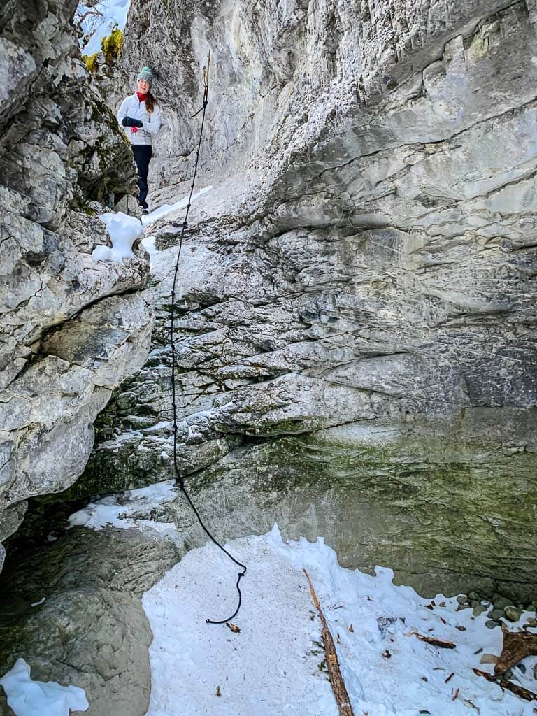
Remembering the Old McGillivray Canyon Obstacle Course
Prior to 2021, the McGillivray Creek and Canyon trail was a little-known Kananaskis winter hike. Alberta slot canyon enthusiasts would add infrastructure (like ropes, and ladders) to the lower McGillivray Creek slot canyon, allowing winter hikers to enjoy maneuvering up and over the dry waterfalls.
In early 2021, word got out about this amazing Kananaskis winter hike and its popularity exploded. The tiny parking lot regularly overflowed and hikers illegally parked on the side of the TransCanada Highway.
In March 2021, Alberta Parks put a stop to this and put up this notice at the McGillivray Creek and Canyon trailhead.

To be fair to Alberta Parks, the McGillivray Canyon trail is not official or sanctioned, and having so many people taking daily safety risks was probably not a good idea.
But, we’re still very sad about the removal of the McGillivray Canyon Obstacle Course – it was a ton of fun! Here are a few of our favorite pictures of the lower McGillivray Creek slot canyon.


If you are looking for an alternate slot canyon hike near McGillivray Canyon, check out the Grotto Canyon Trail or Jura Creek Trail. Grotto Canyon is especially fun in late winter/early spring as an icewalk!
We hope you love the McGillivray Canyon Kananaskis winter hike as much as we do!
Support Human Created Content

Hi, we’re Dan & Celine Brewer, locals from just outside Banff National Park. Every article, itinerary, and recommendation we share is rooted in our real experiences and love for this place. If you’ve found our content helpful, please consider supporting us:
- Make a small donation: Your support directly fuels our work and keeps our stories genuine.
- Purchase a guide or itinerary: Essential tools that help plan your trip and support local creators at the same time.
- Book lodging or tours through our affiliate links: You pay the same price, but we earn a small commission that helps us keep producing content.
Thank you for valuing authentic, human-created content. Your support allows us to help even more Banff travellers!

Dan Brewer, a life-long Alberta resident, calls Canmore home along with his wife and two kids. He is the co-owner of Travel Banff Canada, where he gets to share his passion for the Canadian Rocky Mountains. Dan, along with his family, love being outdoors doing one of the many activities they enjoy in the mountains: hiking, mountain biking, paddleboarding, skiing, snowshoeing and cross-country skiing.
When he's not in Canmore enjoying one of his favourite local hikes, you can find him hopping on a plane to explore a new country with his family or working on one of their other two travel sites: Family Can Travel and Baby Can Travel.