The Yates Mountain Trail is a popular and rewarding Kananaskis hike from the Barrier Lake day use area. One of the best hikes in Kananaskis, the Yates Mountain Trail offers outstanding views of Barrier Lake and the stunning Rocky Mountains of Kananaskis Valley.
Most hikers on the Yates Mountain Trail do it as an out-and-back hike, but we recommend combining it with the Prairie View Trail and Jewell Pass Trail to make this an outstanding loop trail.
To help you decide, this post describes both options for the Yates Mountain Trail.

This post contains compensated links.
Alternate Names for the Yates Mountain Trail
Just to make things more confusing, the Yates Mountain Trail goes by a variety of alternate names:
Yates Mountain (via Prairie View Trail): Is the name the AllTrails hiking app calls the there-and-back hike to the Yates Mountain Lookout. We call this route the Yates Mountain Trail in this post.
Jewell Pass via Prairie View Trail: Is the name AllTrails uses for the full Yates Mountain Loop Trail we describe in this post. We call this route the Yates Mountain Loop Trail in this post.
Prairie View Trail: Is what Alberta Parks calls the hike up Yates Mountain all the way to the Jewell Pass trail junction.
Barrier Lake Lookout Trail: The Yates Mountain Trail doesn’t actually go to the summit of Yates Mountain. There is an unmaintained trail from the upper viewpoint to the Yates Mountain summit where there is a fire lookout. The hike to the Yates Mountain fire lookout is often called Barrier Lake Lookout Trail.

Yates Mountain Hike Highlights
Leg 1 – Road Alongside Barrier Lake
The Yates Mountain hike begins from the Barrier Dam Day Use area along a wide, flat service road along the shores of Barrier Lake. This section of the Yates Mountain hike is very flat with no vegetation to block your views.
You’ll enjoy outstanding Kananaskis mountain views of the rugged Twin Towers, Skogan Peak, Mount Baldy and Mary Barclay’s Mountain across the waters of Barrier Lake.

Adding to the beauty of this section of the Yates Mountain hiking trail is an abundance of mountain wildflowers such as Indian paintbrushes, wild roses and a variety of beautiful yellow and purple flowers.
This first section of the Yates Mountain Trail is technically a portion of Prairie View Trail, which is also part of the TransCanada Trail. I always love a chance to hike along this epic coast-to-coast hiking trail!
The hiking trail starts to climb a bit after the first 1km as you enter an aspen forest. Shortly you’ll come to a four-way trail junction. It’s a bit too early in the Yates Mountain Trail to need a break, but if you want to soak in the Kananaskis scenery there’s a bench at this junction with beautiful views of Barrier Lake and Mount Baldy.

Turn left at the junction if you wish to continue along the shoreline of Barrier Lake towards Jewell Bay Campground. Otherwise, go straight to continue hiking the Yates Mountain Trail.
Leg 2 – Ascending Yates Mountain Trail
For the next 3.5km along the Yates Mountain trail you’ll enjoy a walk through a beautiful dense forest with a mixture of Buffaloberry bushes mixed with aspen and evergreen trees.

This section of the Yates Mountain trail is approximately 6 feet wide most of the way up which makes it a great Kananaskis hike for families, groups or social distancing. This section of the Yates Mountain Trail is the steepest section of the hiking route with a series of eight switchbacks. You’ll get a good sweat going on this leg of the hiking trail.
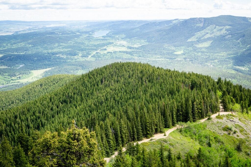
Leg 3 – Yates Mountain Ridgeline
At the 4.4km mark of the Yates Mountain Trail take the left fork at the Y-intersection (the trail sign will call this hiking route the Prairie View Trail).
(If you choose to go right, you’ll descend down the north face of Yates Mountain then work your way along the western base until you return to Barrier Lake).
From here, the Yates Mountain Trail follows a ridgeline in a slow, but steady ascent to the top of the hiking trail. Amazing vistas of Barrier Lake start appearing through the trees.
This is an especially beautiful leg of the Yates Mountain hike, especially in the morning when the sun shines through the trees. The birds are chirping, Old Man Lichen dangles in the wind off the evergreen trees and you’ll see lots of beautiful clematis flowers in the bushes.

We saw the most incredible tree with white flowers during this leg of the hike – I’ve never seen one like this before and I have no idea what it is!
Leg 4 – Yates Mountain Lookout #1
At the 5.2km mark of the Yates Mountain Trail you’ll reach a clearing along the ridge where you will literally stop dead in your tracks. The views looking south over Barrier Lake surrounded by jagged Rocky Mountains are simply incredible.
From this viewpoint, you can see Mount Baldy, Wasootch Ridge (one of our favorite Kananaskis hikes!), Kananaskis Peak, Wasootch Peak and even a tiny bit of Mt. Lorette.

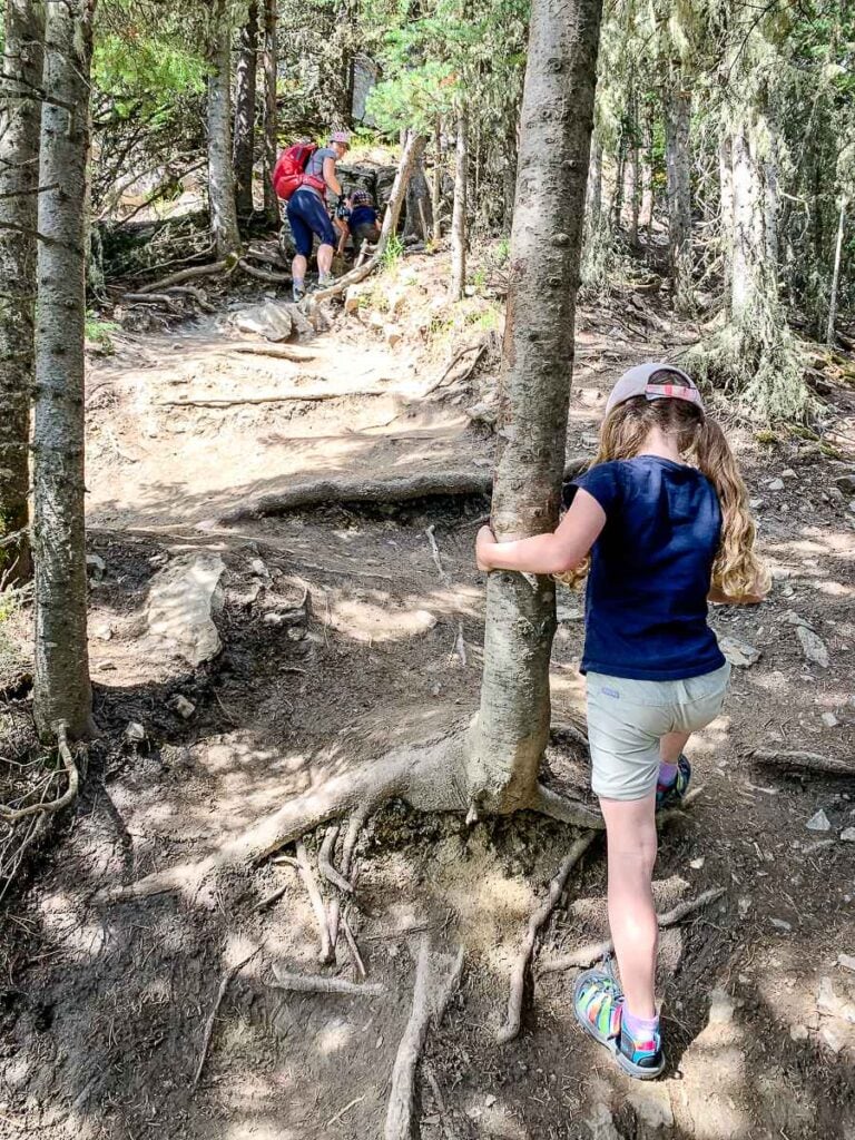
The final 0.5km to the top of the Yates Mountain hike is short, but very steep – it’s a real grind! The final push to the top of the Yates Mountain hike is very rocky with lots of tree roots to navigate.

Leg 5 – Yates Mountain Lookout #2
At the top of the Yates Mountain Trail, you’ll be rewarded for your efforts with incredible views of Kananaskis in every direction. There’s tons of rocks to sit down on and soak in some of the best scenery in Kananaskis.

As always on a popular hike, there’s tons of chipmunks begging for food at the top. Please help keep them healthy and wild by not feeding them human food.
Optional Leg #1 – Barrier Lake Lookout Trail
If you’d like to officially summit Yates Mountain to see the Barrier Lake Fire Lookout, there’s an unmaintained trail heading north from here. It’s approximately another 600m of hiking with an additional 100m of elevation gain.

Optional Leg #2: Yates Mountain Loop Trail
Optional Leg #2A – Descend into the Forest
After reaching the viewpoint at the top of the Yates Mountain Trail, you have a choice on how to get back to the Barrier Lake Day Use Area. Many Kananaskis hikers choose to go back the way they came, but we recommend making this a loop by continuing your hike westward from the top.
To make this excellent Kananaskis hike a loop, from the upper Yates Mountain viewpoint, look westward and downhill for blue posts with orange diamonds.

Try not to get too distracted by the beautiful views of the Twin Towers as the trail has a little bit of loose scree here, making the descent a bit slippery. It’s interesting to know that you can see a tiny sliver of Canmore’s Three Sisters mountain in the distance, just to the left of the trees on Yates Mountain.
Optional Leg #2B – Prairie View Trail – Downhill through the Forest
Before long you’ll officially be on the Prairie View Trail as you reenter the forest. This is a really fun, winding downhill trail through the trees. This 2km section of Kananaskis hiking trail primarily follows the path of a ravine down the south-west face of Yates Mountain.
Optional Leg #2C – Jewell Pass Trail
At the 7.7km mark of the Yates Mountain Loop Trail (via the Prairie View Trail) you’ll reach a 4-way junction. Going straight or right will take you to the Quaite Valley Campground and onwards to the TransCanada Highway via the Quaite Valley Trail.
To return to the Barrier Lake Day Use area, turn left onto the Jewell Pass Trail which, by the way, is also part of the coast-to-coast TransCanada Trail.

The first kilometer of the single-file Jewell Pass Trail is reasonably flat with a few minor ups and downs. At the 8.8km mark of the Yates Mountain Trail, you meet up with another ravine and the hiking trail becomes more visually interesting and fun.
At 9.2km, you’ll cross your first little wooden bridge. At 9.4km you’ll reach a large steel bridge over a beautiful waterfall (which is especially beautiful when frozen).
For a better look at the Jewell Pass waterfall, just keep following the trail downhill as it winds around and ends up near the bottom of the waterfall where you can get an excellent look.

The Yates Mountain Loop/Jewell Pass Trail is especially beautiful beyond the waterfall as it stays near the bottom of a ravine following the path of the river towards Barrier Lake. Before long Barrier Lake and her beautiful companion mountains come back into view.
Optional Leg #2D – Barrier Lake Northern Shoreline
At the 10.8km mark of the Yates Mountain Loop Trail you’ll reach a T-intersection at the end of the Jewell Pass Trail. A few hundred meters to your right is the Jewell Bay Backcountry Campground. Turn left to return to hike along the lakeshore the Barrier Lake Day Use Area.
The lakeside trail back to the Barrier Lake parking lot is quite beautiful looking through evergreens and aspen trees at Barrier Lake and Mount Baldy (just ignore the powerlines).

At the 11.6km mark of the Yates Mountain Loop Trail you’ll arrive at another Y-intersection where you have your final decision to make.
If you go left, you’ll enjoy a nicely groomed hiking path, but you’ll have to walk uphill again through the trees for approximately 1.6km. If you take this route, watch for the right-hand turn which takes you back down to the wide road leading to the Barrier Lake Day Use area.
If you go right, as we did, you’ll stay along the shores of Barrier Lake. The scenery is much nicer along this stretch but there are a few very short, very steep sections. If you’re a good enough hiker to make it this far in the Yates Mountain Loop Trail, you won’t have any issue with these little challenging sections.
Watch for the bench by the final intersection to turn right back towards the Barrier Lake parking lot.
Yates Mountain Trail Location
The official Yates Mountain trailhead is located at the north end of the huge Barrier Lake parking lot. It’s a one hour drive from central Calgary to Barrier Lake and 45 minutes from Banff.

Despite the size of the Barrier Lake parking lot, it fills up very quickly on weekends and holidays. During the busy season, Alberta Parks will often have parking control here to prevent visitors from parking on Kananaskis Highway 40.
As Barrier Lake is in Kananaskis Country, you will need a Kananaskis Conservation Pass to park here.
Try to arrive for your Barrier Lake hike as early in the day as possible. If the Barrier Lake parking lot is full, rather than park on the highway, consider driving a little further to Wasootch Ridge – it’s a bit harder (ie: steeper), but it’s one of our favorite Kananaskis hikes. Ribbon Creek to Ribbon Falls is another solid alternative to the Yates Mountain Trail.
Yates Mountain Trail Stats
How Long is the Yates Mountain Hike?
The round-trip distance of the out-and-back Yates Mountain Trail is approximately 12.3km. If you elect to make Yates Mountain a loop trail via Jewell Pass, the full distance becomes 15.9km long.
Again, if you have the time and energy to go the extra 3.5km, making your Yates Mountain hike a loop gives a ton of new scenery for not much incremental effort.
How Steep is the Yates Mountain Trail?
The total elevation gain you’ll encounter along the there-and-back Yates Mountain Trail is 601m.
If you hike the Yates Mountain Loop Trail, it’s mostly downhill all the way back to the Barrier Lake parking lot. There are a few minor uphill sections along the way, which results in a total elevation gain of 823m.

How Hard is the Yates Mountain Hiking Trail?
The Yates Mountain Trail is one of the most popular hikes in Kananaskis. On any given day of the year, you’ll see tons of families enjoying this beautiful hike near Canmore. One of the many reasons Yates Mountain Trail is so popular is that virtually anyone who is in decent shape can enjoy this hike.
The Yates Mountain Trail has a steady incline from the moment you leave the shores of Barrier Lake until you reach the viewpoints at the top. There’s a short, but challenging leg near the top which is quite steep and has lots of rocks and roots.
Due to its length and elevation gain, we’d rate the Yates Mountain Trail as a “moderate” Kananaskis hiking trail.
The extra 3.5km you’ll hike if you complete the Yates Mountain Loop Trail is mostly easy, downhill hiking trail, so we’d maintain the “moderate” difficulty rating for the full loop.
How Long Does It Take to Hike Yates Mountain?
It should take a typical adult about 2.5 hours to hike the out-and-back Yates Mountain Trail. When we recently hiked the Yates Mountain Loop Trail it took us just over 3.5 hours to hike.
If you hike the Yates Mountain Trail with kids, expect it to take longer. We recently hiked the Yates Mountain Trail with our kids (aged 4 & 6) and it took us around 4.5 hours.

Yates Mountain Trail Map
As you can see from the Yates Mountain Trail highlights above, there are lots of trails in-and-around Barrier Lake and Yates Mountain. The trails are reasonably well marked with Alberta Parks trail signs, but we recommend having a trail map on your phone to ensure you stay on the Yates Mountain Trail.

We used the AllTrails app while hiking the Yates Mountain Loop Trail. It came in very handy for navigation purposes at many of the trail junctions. In addition to helping stay on the trails, we like the ability to track our stats (distance, elevation gain, etc.).
To find the out-and-back Yates Mountain hiking map on AllTrails, simply click on the link for the “Yates Mountain via Prairie View Trail Map”.
To find the full Yates Mountain Loop hiking map on AllTrails, click on this link for “Jewell Pass via Prairie View Trail“. This is the Yates Mountain trail map we used on our most recent Yates Mountain Loop hike.
Being so close to Canmore and the TransCanada Highway you should have some cell service on this Kananaskis hike, but expect it to be spotty. It’s always a good idea to download the trail map onto your phone ahead of time just in case.
A recent App of the Year winner, AllTrails is also one of the best apps for visiting Banff! Enjoy map downloads and many more premium features with a 7-day free trial of AllTrails+!

Hiking Yates Mountain Trail with Kids
The Yates Mountain hike is one of the best hikes in Kananaskis. It’s a bit harder than your typical ‘kid-friendly Kananaskis hikes‘, but on any given day you’ll see lots of families enjoying the hike up Yates Mountain.

Kids will love the first kilometer along the shoreline of Barrier Lake. The wide-open trail is irresistible to kids who love to run ahead and play. The uphill portion through the forest may present some challenges with kids as they start to tire out. Keep them motivated with promises of snacks at the top.

The final 0.5km from the lower Yates Mountain lookout to the upper lookout is a ton of fun for kids. It’s really steep with lots of roots and rocks to navigate. This part of the Yates Mountain hike is like a fun little obstacle course for them. It’s hard, but our kids loved it!
Where to Stop for Lunch or a Break
If you prefer a proper sit-down picnic, you’ll find lakeside picnic tables and park benches around the Barrier Lake Day Use parking lot.
There’s also a bench on the Yates Mountain Trail just as the hiking trail leaves the shores of Barrier Lake. This bench is in the midst of a beautiful aspen forest with some nice views of Barrier Lake and the surrounding mountains.
But, of course, the best place to stop for lunch on this excellent Kananaskis hike is at one of the two viewpoints at the top of the Yates Mountain Trail. After a good workout getting to the top, plop down your hiking picnic blanket and enjoy some of the best Kananaskis views anywhere!

Yates Mountain Hiking Safety
Kananaskis Country is prime bear and cougar habitat. There are plenty of Buffaloberry bushes along the trail, which are a magnet for bears as they fatten up in late summer. Please take the time to educate yourself about bear safety and cougar safety in Kananaskis Country.
We recommend you check the latest Prairie View trail report for trail conditions, wildlife warnings and possible closures before you head out. If you intend to hike the full Yates Mountain Loop, check out the Jewell Pass trail report as well.

Wildlife Safety
When hiking in Kananaskis Country, you are responsible for your own safety. Before hitting the hiking trails, we highly recommend reading our Essential Kananaskis Hiking Tips for information about bear safety, trail conditions, wildlife warnings and possible closures.
Yates Mountain Trail Logistics
On-leash dogs are allowed on the Yates Mountain hike. This hike is so popular, that it’s one of the rare Kananaskis hikes where people actually keep their dogs on leash.
There are multiple washrooms in the Barrier Lake parking lot.
There are no drinking water facilities at Barrier Lake or on the Yates Mountain Trail, so fill your reusable water bottles or hydration packs before you leave home.
You might get some cell service from Canmore or Kananaskis Village, but don’t count on it.
There is a bike rack in the Barrier Lake parking lot near the Yates Mountain trailhead.

What to Bring Hiking on Yates Mountain Hike
As the Yates Mountain Trail is a moderate Kananaskis hiking trail, you need to be properly prepared for a day of safe hiking in the mountains. Before hitting the trail, please take the time to review our recommended Kananaskis hiking equipment.


Yates Mountain Hike in Spring
The Yates Mountain hiking trails are on the south face of the mountain, ensuring it gets plenty of sunshine in Spring. The southern exposure helps melt snow early in the season, making Yates Mountain a good option for a spring hike in Kananaskis. We have hiked Yates Mountain Trail in spring as early as mid-March and on Father’s Day in June.
In March, most of the Yates Mountain trail will still be covered in ice and/or snow. Winter traction devices (such as micro spikes) are a must during this time of year as you’ll have extreme difficulty on some of the steeper slopes without them.

In June, the Yates Mountain trail is mostly dry with a few muddy patches along the way. The recently melted snow creates moist conditions which mosquitos love, so bring lots of insect repellant.

We hope you enjoy the Yates Mountain Loop trail in Kananaskis as much as we do!
Support Human Created Content

Hi, we’re Dan & Celine Brewer, locals from just outside Banff National Park. Every article, itinerary, and recommendation we share is rooted in our real experiences and love for this place. If you’ve found our content helpful, please consider supporting us:
- Make a small donation: Your support directly fuels our work and keeps our stories genuine.
- Purchase a guide or itinerary: Essential tools that help plan your trip and support local creators at the same time.
- Book lodging or tours through our affiliate links: You pay the same price, but we earn a small commission that helps us keep producing content.
Thank you for valuing authentic, human-created content. Your support allows us to help even more Banff travellers!
Love our content? Sharing our post is the easiest way to support us!


Dan Brewer, a life-long Alberta resident, calls Canmore home along with his wife and two kids. He is the co-owner of Travel Banff Canada, where he gets to share his passion for the Canadian Rocky Mountains. Dan, along with his family, love being outdoors doing one of the many activities they enjoy in the mountains: hiking, mountain biking, paddleboarding, skiing, snowshoeing and cross-country skiing.
When he's not in Canmore enjoying one of his favourite local hikes, you can find him hopping on a plane to explore a new country with his family or working on one of their other two travel sites: Family Can Travel and Baby Can Travel.