Kananaskis Country has long been one of our favorite places to go hiking. It’s a place where you can find hikes to satisfy all levels of fitness without having to look very hard. In this list of easy Kananaskis hikes you’ll find some of our favorites.
We’ve done these easy hikes in Kananaskis so many times with family and friends of all different ages. As locals, these are some of our go-to Kananaskis hikes when we want to take visiting family somewhere scenic without overwhelming them with a long or difficult trail. We’ve also done all of these easy hikes with our kids, from babies to middle school-aged kids. These easy hiking trails in Kananaskis are the ones we come back to year after year.

This post contains compensated links.
A Note About Difficulty
It’s important for first-time mountain hikers to understand that an “Easy hike in Kananaskis” will still have some uphill walking. These are the best of the easiest hikes in Kananaskis, but if you are new to hiking in the mountains, you may still find them challenging.
These hikes are among the easiest you will find in the rugged Rocky Mountain landscape of Kananaskis Country. If you are worried about the difficulty, we recommend you start with Troll Falls or the Montane Interpretive Trail. Once you assess your capabilities to these relatively easy trails, you can decide which of these other easy Kananaskis trails are right for you.

Don’t miss out on ANYTHING in Banff!
Our comprehensive Banff Travel Guide has EVERYTHING you need to plan the best trip without feeling overwhelmed or that you’ll miss out.
Included as part of our Banff & Jasper Planning Hub, you’ll get access to all our itineraries, the Banff Guide, printable itineraries, live Q&A support and replays!
Best Easy Hikes in Kananaskis
These easy Kananaskis hikes are short, scenic trails that deliver mountain views, lakes, waterfalls, canyons or forest walks without a major elevation gain. It’s nearly impossible to rank them in order of best-to-worst, as we enjoy all of these hikes. But we’ve done our best to rank them in the order that we enjoy them most.
Note: A Kananaskis Conservation Pass is required if you park a vehicle at these trailheads in Kananaskis Country or the Bow Valley corridor.
1. Grassi Lakes
Distance: 4.0 km out & back
Elevation: 170 m
Grassi Lakes is often included in lists of the best things to do in Canmore with kids or easy Canmore walking trails, but it is technically located in Kananaskis Country. Regardless, the Grassi Lakes hike is a popular hike and for good reason; it’s one of the best easy hikes in Kananaskis. On a sunny day, the water colour of Grassi Lakes is simply incredible.

Hikers only need to hike 2 km to experience the incredible Grassi Lakes with their stunning blue-green colour. And while there is some uphill climbing, it’s a fairly gentle incline along a wide gravel road.
Just past the start of the Grassi Lakes Trail there is an option to take a more difficult trail, which can be combined with the easy path to make a loop. Take this Grassi Lakes trail to get some views on the way up, but be prepared for a very short, steep section on the way up.
Once at the top, take the time to marvel at the stunning Grassi Lakes and enjoy a slow meander around the lakes.

Please respect all the signs and stay on the path. There is a lot of area around the Grassi Lakes that is under restoration. With the towering rock cliffs around Grassi Lakes, some areas are rockfall hazards. Obey all “Area Closed” signs.
Read More
We love visiting Grassi Lakes. You can learn more about the Grassi Lakes Trail in our full blog post.
2. Blackshale Suspension Bridge
Distance: 6.1 km out & back
Elevation: 333 m
While most won’t have much to say about the actual hike to the bridge, we think it’s a pleasant walk along an undulating trail in the forest. While the views are sparse, a trail like this one that’s mostly in the forest is a good choice for a windy day.

The Blackshale Suspension Bridge is a fun reward at the end of the hike, but you don’t have to stop there. Once at the bridge, you can continue along the High Rockies Trail as long as you want or turn back to complete the Blackshale Suspension Bridge hike.
The Blackshale Suspension Bridge is quickly becoming a very popular thing to do in Kananaskis Country. The suspension bridge can get very crowded with hikers taking their time crossing the wobbly bridge and taking pictures. Be aware there is a safety limit of 20 people on the suspension bridge at any time. To avoid the crowds, get there as early as possible.

The suspension bridge over Blackshale Creek is closed in the winter, so Alberta Parks built a bypass trail allowing you to continue along the High Rockies Trail without using the bridge.
Many people use this shortcut to visit the Kananaskis suspension bridge. Using the High Rockies winter bypass trail shortens the round-trip distance to the Blackshale Suspension Bridge from 6.1 km to just 1 km. However, we find the walk through the forest enjoyable and recommend doing it that way.
Read More
Visiting the Blackshale Creek Suspension Bridge is one of the most unique and fun things to do in Kananaskis Country.
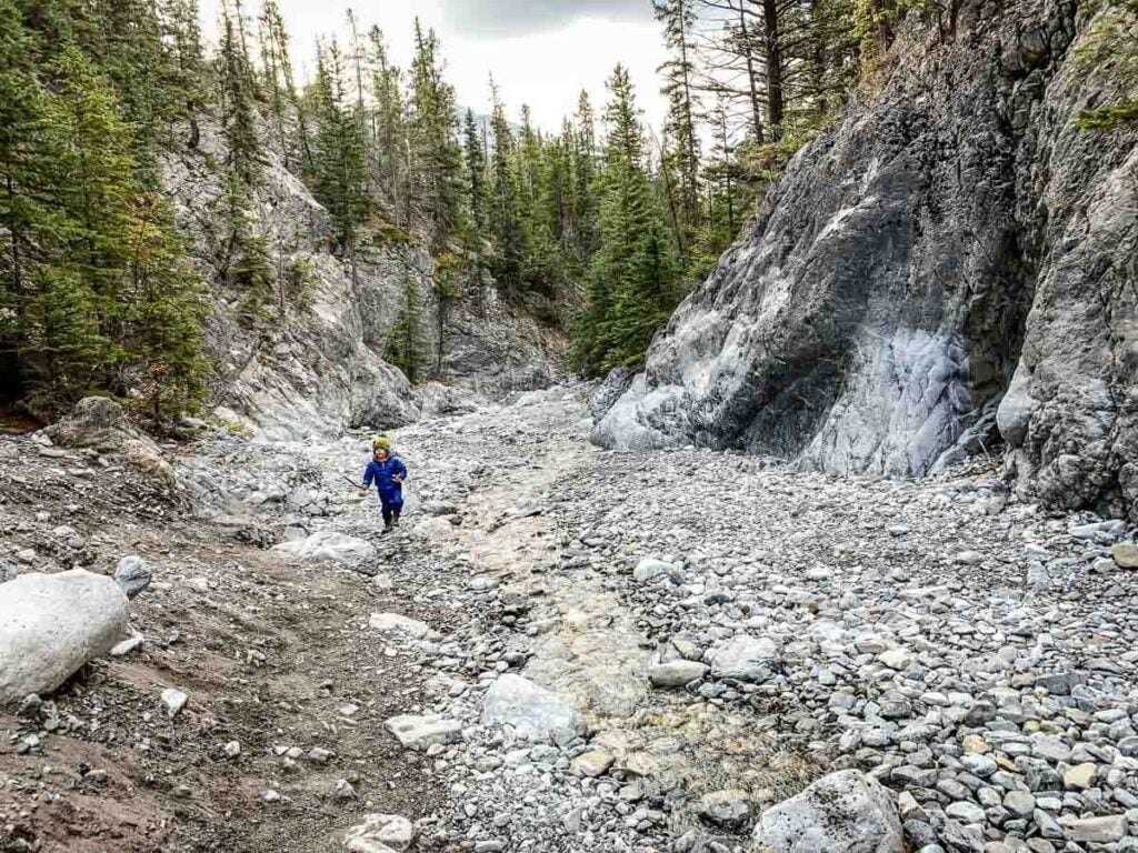
3. Grotto Canyon
Distance: 5.2 km out & back
Elevation: 259 m
The trail to Grotto Canyon starts out along an access road complete with a powerline and the Baymag magnesium oxide plant in the distance. It’s not the most scenic start to a hike. Don’t worry, this section is only about 0.8 km before the trail makes a right turn into the trees.
After passing the bench and an open mountain view, you’ll soon enter Grotto Canyon and the first 0.8 km of the hike will be a distant memory.
Safety Tip
Avoid hiking in the canyon if heavy rain is possible, as rushing water can carry rocks and debris through the canyon.
As you enter Grotto Canyon, you’ll be following the creek upstream between two vertical cliffs. If you are hiking Grotto Canyon in spring you can expect a large portion of the hike to be jumping across the flowing creek.
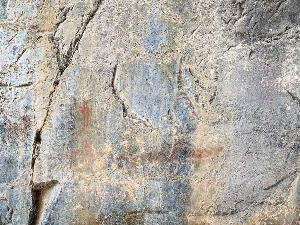
Another fun part of Grotto Canyon is finding the pictographs. As you near the Grotto Canyon waterfalls, look to the left to see some pictographs of humans and animals, thought to be drawn between 500 to 1,300 years ago by the Hopituh Shi-nu-mu people (“Hopi” for short).
Read More
This canyon is super fun in the winter! In fact, doing the Grotto Canyon Ice Walk is one of our favorite things to do in Kananaskis in winter.
4. Heart Creek Trail
Distance: 4.7 km out & back
Elevation: 300 m
The Heart Creek Trail is an enormously popular and easy Kananaskis hike. It’s popular for a reason: Heart Creek is fun, easy and beautiful, with enough variety to appeal to almost everyone.

Wildlife Safety
When hiking in Kananaskis Country, you are responsible for your own safety. Before hitting the hiking trails, we highly recommend reading our Essential Kananaskis Hiking Tips for information about bear safety, trail conditions, wildlife warnings and possible closures.
Hikers follow the path of the gently flowing Heart Creek into the belly of a dramatic mountain canyon, filled with large evergreen trees and boulders on the canyon floor. The many wooden bridges over Heart Creek keep the trail interesting the whole way.
At the end of the Heart Creek hike is a very popular picnic spot. It’s a beautiful spot, next to a rock wall with a loud, hidden waterfall tucked just out of sight. There are a few park benches here, with lots of spots to relax and enjoy the beauty of this special Kananaskis spot.

Heart Creek Trail is also an easy winter hike in Kananaskis and we recommend experiencing this spot covered in a blanket of snow. If you go in winter, we recommend you wear some winter traction devices on your boots.
To avoid the crowds, hike Heart Creek early in the morning, late in the afternoon or on a weekday.
Read More
Heart Creek has been one of our favorite easy hikes in Kananaskis for a long time. Discover everything you need to know in our full post on the Heart Creek Trail.
5. Heart Creek Bunker
Distance: 4 km out & back
Elevation: 212 m
Since Heart Creek Trail is such a short hike, you may still have time to fit in the nearby Bow Valley Bunker, also known as the Heart Creek Bunker. The Heart Creek Bunker leaves from the same parking lot as Heart Creek Trail, but from the west end of the parking lot.

Read More
You’ll need to be properly prepared for your outing, even if you are just doing an easy hike in Kananaskis. Check out our guide to the essential Kananaskis hiking gear.
The Heart Creek bunker hike is another easy Kananaskis hike with a fun payoff. Hiking 2 km will take you to a Cold War era bunker carved deep into the side of Mount McGillivray.
Built in the 1960s, the Heart Creek Bunker goes 55 m deep into the mountain, with a side channel over 40 m long. It was designed to protect the nation’s critical documents against a catastrophic emergency, such as a hydrogen bomb.
The Heart Creek bunker hike itself is nothing special, but venturing into the cold, damp and VERY dark cave is incredibly fun for everyone. Make sure everyone has their own powerful flashlight or headlamp. It’s extremely dark inside.
Read More
We don’t have a blog post on the Heart Creek Bunker Trail quite yet. In the meantime you can get a trail map on AllTrails (one of our favorite apps for the Canadian Rockies).
6. Troll Falls
Distance: 3.5 km out & back
Elevation: 110 m
Troll Falls is one of the best and easy hikes in Kananaskis. The only real knock on Troll Falls is its popularity. The short 3.5 km Troll Falls hike near Kananaskis Village has a little bit of everything. The wide trail takes you along a forested trail that opens up part-way through for some mountain views.

The nice wide trail makes this an excellent kid-friendly hike in Kananaskis. Kids will have plenty of room to play the entire way. If you look into the forest along the trail, there are often some teepees that kids will enjoy playing in.
From there, you’ll cross a bridge and continue through an aspen forest, which makes this a very pretty fall hike in Kananaskis.
The trail narrows after this point up until the waterfall. There’s a newly built viewing deck to see the impressive waterfall at a safe distance. There’s the option to venture to the upper falls as well, before turning back.

The Troll Falls is technically an out-and-back trail, but it can be combined with the Hay Meadow Trail to make it a 4 km loop.
Troll Falls is a year-round hike and hiking Troll Falls in the winter is well worth it to see the frozen waterfall.
Read More
For more information about why this is such a popular, easy Kananaskis hike, check out our post on the Troll Falls Hike.
7. Hay Meadow (Add-on to Troll Falls)
Distance: 3 km out & back
Elevation: n/a
The Hay Meadow Trail leaves from the same parking lot as Troll Falls and Stoney Trail, both of which can be combined with the Hay Meadow Trail to make a loop. Hay Meadow Trail starts underneath the power lines across from the Troll Falls trailhead. The Hay Meadow trailhead is marked by a faded green sign with an arrow and a “no horses” sign.
The easy Kananaskis hiking trail starts out in the forest along a nice flat and wide trail. In fact, the entire length of the Hay Meadow Trail is so flat, you’ll barely notice an elevation change.
Not long into the hike you’ll reach the Kananaskis Golden Eagle migration count site. Here you’ll find some interesting interpretive signs about the annual Golden Eagle migration count which occurs at this spot between March 1 – April 22 every year.

To increase your chances of seeing a Golden Eagle migrate through Kananaskis on its way to the Yukon or Alaska, try visiting in the late afternoon when Golden Eagle activity is highest.
For more information on the annual Golden Eagle count in Kananaskis, visit eaglewatch.ca. Please consider making a donation to help keep this important Golden Eagle migration study going.
The Hay Meadow Trail continues along the shores of the Kananaskis River with impressive mountain views and a meadow on your left. Eventually it veers left and will intersect with Stoney Trail (where the powerline runs) with views of The Wedge (2,667m) to the left, while to the right you’ll be treated to equally nice views of Mt. Lorette (2,469m).

Shortly after, you’ll intersect with Troll Falls. You can continue on Troll Falls to make a loop or return back the way you came.
Read More
We describe the Hay Meadows Trail in great detail in our blog post about the Troll Falls Trail.
8. Montane Interpretive Trail
Distance: 1.6 km loop
Elevation: 58 m
The Montane Interpretive Trail is a kid-friendly Kananaskis hike that packs a ton of excellent scenery in a very short distance of 1.6 km.

The Montane Trail begins in a mixed forest of evergreens and aspens, then opens into a series of meadows. The first of many interpretive signs appears here describing life for the flora and fauna of the montane ecosystem of the Bow Valley Provincial Park.
It’s not long before you’ll find yourself re-entering the forest before a scenic viewpoint with a bench. The remainder of the hike stays in the forest.

One benefit of hiking the Montane Trail is that the Bow Valley paved pathway starts from the same parking lot. This easy bike ride in Kananaskis is the perfect addition to the short hike on the Montane Trail.

For anyone camping in Kananaskis, that same paved pathway connects the Montane Trail to the Bow Valley Campground near the camp store. This is a fun and scenic bike ride that is well worth it.
Read More
This easy Kananaskis hike was another trail we enjoyed frequently with our kids. Learn more in our full blog post on the Montane Interpretive Trail.
9. Many Springs Interpretive Trail
Distance: 1.5 km loop
Elevation: n/a
The Many Springs Interpretive Trail is in the Bow Valley Provincial Park area of Kananaskis. This easy Kananaskis hike can be paired up with the many other short hikes nearby.
If you’ve ever hiked Many Springs, you can attest to the fact that this short hike is immensely enjoyable and well worth it. After a short 0.3 km, you’ll turn either right or left to begin the loop around a spring-fed pond. This trail should be popular with both wildflower enthusiasts and bird watchers.

Kids will also love this easy Kananaskis hike. The trail crosses a bridge over Many Springs Creek with impressive river and mountain views opposite the pond. From there a short jaunt takes you through the forest then onto a fun boardwalk across the wetlands.

On the other side, there’s a small dock where you can truly appreciate this beautiful area. It’s just a short distance from here to complete the loop and return back along the short spur trail to the parking lot.
Read More
When our kids were little, this was one of our favorite family hikes in Kananaskis. Learn more about the Many Springs Trail in our blog post.

Let me Help with Your Banff Itinerary?
We have a suite of Banff Travel Planning services that can take all the guesswork out of planning your trip! Book a 1 hour travel consultation or let me create a custom Banff Itinerary for you!
10. Watridge Lake
Distance: 8.6 km out & back
Elevation: 194 m
The Watridge Lake Trail leaves from the Mt. Shark Day Use area just off the Smith-Dorrien Highway. This trail is flat and wide, making it a good hike for families or groups. While wide trails or roads often get a bad rap amongst hikers, this one is quite pleasant with impressive mountain views along the way.

The trail to Watridge Lake can also be done by bike and is a fun kid-friendly bike trail in Kananaskis. While Watridge Lake itself is quite beautiful and is worth the effort, adding on the Karst Spring Trail is what makes this hike truly spectacular.

We highly recommend adding on the extra 0.8 km up the steep trail to Karst Spring. You’ll need to hike to Watridge Lake first, as this is the access point for the Karst Spring Trail.
11. Karst Spring (Add-On to Watridge Lake)
Distance: 1.6 km out & back for Karst Spring PLUS 8.6 km out & back to reach this trail
Elevation: 103 m
While we’d never have a bad thing to say about the trail to Watridge Lake from the Mt. Shark Day Use, the real attraction of this hike is to get to Karst Spring.

The Karst Spring Trail portion adds on an extra 1.6 km out & back (for a total of 10.2 km) and is quite steep in spots. After taking in the stunning lake views, walk along the wooden platforms to cross the marsh.

Local Tip
Bikes are NOT allowed past Watridge Lake, so you’ll need to lock them up before continuing on to Karst Spring. Also, please stay on the boardwalks at all times.
Once you pass the marsh left over from the Karst Spring, you enter the forest. You’ll notice the significant drop in temperature at this point as you approach the forceful Karst Spring waterfall. The force of the water flowing down is impressive!
Continue to follow the trail to the top where you’ll find some interpretive signs and the start of the Karst Spring gushing out of the side of Mt. Shark.
Read More
I am truly blown away every time I see Karst Spring – it’s the most impressive waterfall in Kananaskis Country. Get all the details in our blog post on the Watridge Lake to Karst Spring Trail.
12. West Wind Pass
Distance: 5.4 km out & back
Elevation: 353 m
West Wind Pass is one of our favourite short Kananaskis hikes, with a steady climb along the side of a valley toward a scenic mountain pass. This trail abundantly rewards hikers for their efforts with breathtaking mountain scenery and an incredible view of the Spray Lakes.

Upon reaching the pinnacle of the West Wind Pass Trail, you’ll find yourself at a mountain pass nestled below The Rimwall and Windtower mountains.
Gazing northeast, a panorama of awe-inspiring sights unfolds before you, encompassing Wind Ridge (yet another of our cherished, but very hard Kananaskis hikes), the graceful Little Sister (Hope) from Canmore’s Three Sisters, and the striking Pigeon Peak. This incredible viewpoint is attained with a hike of less than 3 km.

While this is a nice short hike, it does get steep in a few spots. It’s also important to know that it’s typically windy at the pass, so be prepared with layers if you want to spend some time there enjoying the view!
Read More
You won’t find many easy hikes in Kananaskis Country which give views as spectacular as this! Get all the details in our full post on the West Wind Pass Trail.
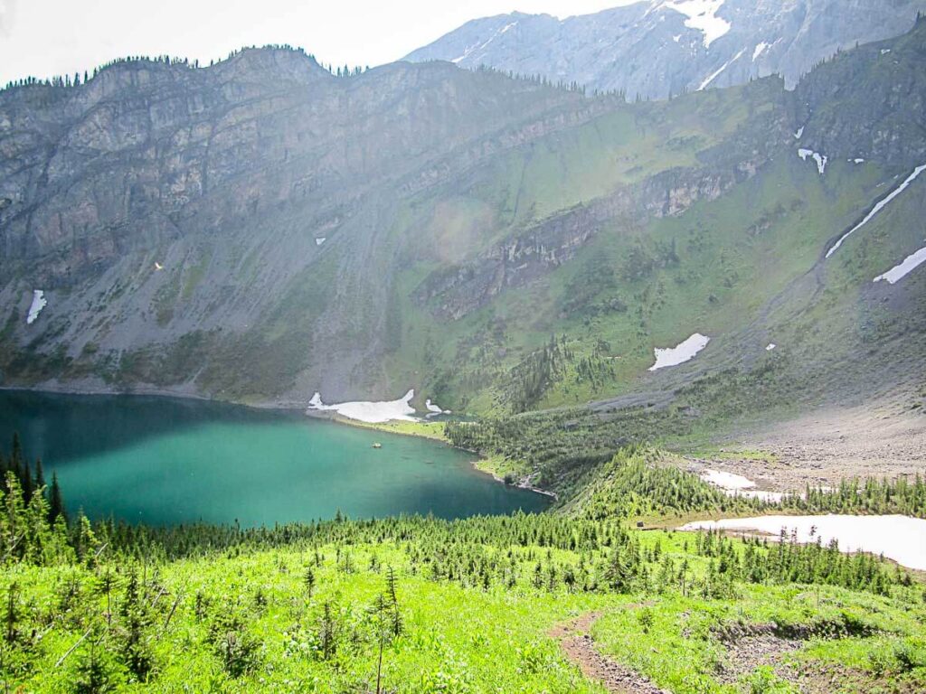
13. Rawson Lake
Distance: 7.8 km out & back
Elevation: 320 m
The Rawson Lake hike is considered one of the best easy hikes in Kananaskis. Hikers heading to Rawson Lake will enjoy being near two beautiful Kananaskis lakes, with an enjoyable forest hike in-between, which can be a bit challenging.

Starting along the Upper Kananaskis Lake Trail, the morning mountain reflections on the lake are quite captivating. The peacefulness of the Upper Lake in the morning encourages you to take your time and enjoy the surroundings.

There are benches along the way that invite you to appreciate the view for longer. While it may seem like a great place to stop, we recommend continuing as the payoff at Rawson Lake is truly rewarding! We have a lot of love for this Kananaskis hike, and we believe you will enjoy it too!
While it’s well worth the effort, the continuous climb may make it feel like a moderate Kananaskis hike for some. It’s also crucial to check the trail report for the Rawson Lake hike as grizzly bears frequent the area between Rawson Lake and the very difficult, but rewarding Sarrail Ridge Trail.
Read More
This is yet another easy Kananaskis hike with stunning scenery. Get everything you need to know in our full post on the Rawson Lake Trail.
14. Ptarmigan Cirque
Distance: 3.6 km loop
Elevation: 267 m
The Ptarmigan Cirque hike is a popular easy hiking trail in Kananaskis, located near the Highwood Pass, which is the highest paved pass in Canada. It’s a fun and kid-friendly hike that offers hikers a variety of beautiful mountain scenery over a relatively short distance.

The hike is known for its scenic beauty and is especially popular during the fall when the larch trees in Kananaskis turn golden. If you time your visit right, you can enjoy hiking through areas with these golden larch trees at the base of a beautiful mountain cirque.

Since it’s such a popular larch hike, it’s a good idea to start early and avoid weekends, as the parking lot also serves as a starting point for other popular trails, like the Pocaterra Ridge Trail.
Read More
This isn’t just a larch hike – it’s a very rewarding, scenic Kananaskis hike all year round. Get more details in our post about the Ptarmigan Cirque hike.
15. Arethusa Cirque
Distance: 4.5 km loop
Elevation: 357 m
Arethusa Cirque, a remarkably scenic short Kananaskis hike near the Highwood Pass, may not be as widely recognized as its neighboring trails like Ptarmigan Cirque or Pocaterra Ridge. Even so, Arethusa Cirque rewards hikers with a surprising amount of Rocky Mountain scenery for a relatively short hike.

Although the trail’s beauty is evident year-round, it truly shines in late September when the allure of Arethusa Cirque surges. This hidden gem is gaining popularity, particularly in early autumn, as it offers an outstanding experience for hikers looking for the best larch hikes in Alberta. It’s best to go early, as the parking lot is small.
Timing your visit just right will lead you through expansive patches of golden larch trees, gracefully adorning the base of the mountain cirque.

With its exceptional beauty and abundance of larch trees, Arethusa Cirque is likely to continue attracting more and more hikers seeking an incredible Kananaskis larch hike. Consider going early if this one is on your list, especially during larch season.
Read More
This is just an overall great easy hike in Kananaskis Country – I really enjoy it every single time. See more pictures and get important details in our post about the Arethusa Cirque hiking Trail.
16. Flowing Water Interpretive Trail
Distance: 2.3 km
Elevation: 79 m
Flowing Water Interpretive Trail is an easy hike in Kananaskis that packs a lot of scenery into a 3 km loop. With views of the Kananaskis River and nearby mountains like Mount Yamnuska and Yates Mountain, you’ll enjoy this short hike the entire way.

The first part of this trail passes through a forest along a creek through the campsite before reaching the official Flowing Water Interpretive Trail sign. At this point, the trail continues along a section up above the banks of the Kananaskis River and where the trees open up you get views of the river in both directions.

It continues up a short uphill with some stairs to make the slope a little easier, before revealing a stunning viewpoint. From there it descends back down through an aspen forest and eventually to a beaver pond. It continues along a boardwalk, with unobstructed mountain views, before returning to the trailhead.
Read More
Learn more about the Flowing Water Trail in our full blog post.
17. Widow Maker Trail
Distance: 4.2 km out & back
Elevation: 128 m
The Widow Maker hike is an easy hike in Kananaskis that takes you along the banks of the Kananaskis River. It’s an out and back hike that can be reached from three separate parking lots: Canoe Meadows Day Use, Barrier Lake Visitor Information Centre or the Widow Maker parking lot.
We recommend parking at the Canoe Meadows Day Use for this easy Kananaskis hike. The Widow Maker Trail is 4.2 km from the Canoe Meadows Day Use to the Widow Maker parking lot. The Widow Maker hiking trail leaves from the far end of the parking lot past the toilets and starts in the trees.

The hike itself is an easy hike that meanders along the bank of the river. It has some pretty views of the river along the way. This Kananaskis hike has some steep drop-offs and gets close to the fast-moving river, so keep kids close.

While this is a short hike, plan some extra time because watching the river surfers, kayakers and whitewater rafters along this trail is the real highlight.
As you approach the Widow Maker parking lot, go down the hill instead of up to the parking lot, to watch kayakers practicing in the rapids. Hikers can even watch slalom canoe/kayak racers near the campground at the Canoe Meadows Whitewater Training Centre.
When we hiked back to Canoe Meadows Day Use, we went left at the road instead of continuing on the trail, which took us along the banks where the slalom race course is set up. This took us through the tent sites and back to the parking lot.

The Canoe Meadows Day Use has a large parking lot, a picnic area and toilets. The Canoe Meadows campground is also located here. It has group camping and individual walk-in tent sites that can be booked on the Alberta Whitewater Association site for anyone interested in camping in Kananaskis.
Read More
While you wait for us to write a full blog post on the Widow Maker Trail, you can hop on over to AllTrails to get a trail map.
18. Black Prince Cirque Interpretive Trail to Warspite Lake
Distance: 4.8 km loop
Elevation: 178 m
The Black Prince Cirque Interpretive Trail is one of two easy Kananaskis hikes that leaves from the Black Prince Day Use parking lot. The Black Prince Cirque Interpretive Trail, which may also be called the Warspite Lake hike, leaves right from the parking lot.

This easy Kananaskis hiking trail starts out along the Warspite Creek and crosses a bridge before veering to the left. After a short distance you’ll turn right and the climbing starts up an old logging road. Though the uphill climb it isn’t all that long, it will still get your heart pumping. There’s a bridge near the top to take a break.

Once the Black Prince Cirque Trail levels off, the trail is much narrower and will take you along a loop through a boulder field and to Warspite Lake. This mountain lake with stunning mountain peaks as the backdrop is more than worth the effort!
Once you return back to the starting point on the loop, turn right and head back down the way you came.
Read More
You can get a trail map and directions to the Black Prince Cirque Trail on the AllTrails app.
19. Middle Lake Interpretive Trail
Distance: 2.5 km loop
Elevation: 85 m
The Middle Lake Interpretive Trail in Bow Valley Provincial Park is an enjoyable easy Kananaskis hike. Hikers along the Middle Lake Trail will enjoy a variety of landscapes including a mountain lake and a pleasant forest setting.

Hike this easy Bow Valley Provincial Park trail on a calm day and you’ll be rewarded with a stunning mountain reflection on the lake. Late spring will reward hikers with wildflowers. Hiking this short Kananaskis hike in the fall, the mountain reflection gets a pop of colour with the changing leaves of the aspen trees.
Once the Middle Lake Trail enters the forest, you’ll appreciate the nice shade from the evergreens as the trail starts to climb very gently.

As you leave the forest behind after 1.9 km of hiking, you reach the shores of the lake again. There are a few benches along the trail to stop and enjoy the excellent Kananaskis views before finishing up this 2.5 km loop.
Read More
This short & easy Kananaskis hiking trail has a little bit of everything. Get all the details in our post on the Middle Lake Trail.
20. Bow River Interpretive Trail
Distance: 5.6 km loop
Elevation: 122 m
The Bow River Interpretive Trail in Bow Valley Provincial Park is a very enjoyable hike along the banks of the Bow River.
The Bow River Trail can be hiked as an out-and-back trail or combined with other Bow Valley trails to make a loop along the Bow River and through the montane forests this part of Kananaskis is known for.

We combine the Bow River Trail with the Whitefish Trail, the Elk Flats Trail and the Moraine Trail. Trust us, it’s well signed and not as complicated as it sounds. Turning the Bow River Trail into a 5.6 km loop provides you with significantly more variety in Kananaskis scenery than simply hiking the Bow River Trail as an out-and-back.
Our iteration of the Bow River hike begins in the beautiful Whitefish Day Use area. Take a few moments to linger by the shores of the Bow River and admire the Rocky Mountain scenery which draws people to this area from all over the world. From this vantage point, you can see unimpeded mountains from Mt. Yamnuska all the way to Canmore’s Three Sisters.

From the Whitefish Day Use, complete the 5.6 km loop by following the 0.4 km Whitefish Trail, the 1.1 km Moraine Interpretive Trail, the 1.9 km Elk Flats Trail and finishing up on the 2.1 km Bow River Interpretive Trail.
Read More
This one is a bit tricky with the many trails to combine into one. We make it easy in our post on the Bow River Trail.
More Easy Hikes Near Kananaskis
If you are looking for more easy hikes near Kananaskis County, why not check out these easy hikes in Banff National Park? Or, if you are looking for something a little more challenging, you should take a look at our post on the Best Hikes in Kananaskis.
Support Human Created Content

Hi, we’re Dan & Celine Brewer, locals from just outside Banff National Park. Every article, itinerary, and recommendation we share is rooted in our real experiences and love for this place. If you’ve found our content helpful, please consider supporting us:
- Make a small donation: Your support directly fuels our work and keeps our stories genuine.
- Purchase a guide or itinerary: Essential tools that help plan your trip and support local creators at the same time.
- Book lodging or tours through our affiliate links: You pay the same price, but we earn a small commission that helps us keep producing content.
Thank you for valuing authentic, human-created content. Your support allows us to help even more Banff travellers!
Love our content? Sharing our post is the easiest way to support us!


Celine Brewer, a local Canmore resident, is the co-owner of Travel Banff Canada. She has a passion for being out in the mountains any time of year. In the summer, you'll often find her hiking or mountain biking. In the winter, she enjoys cross-country skiing, snowshoeing and winter hiking the most.
As much as she loves the mountains, she also loves travel! When she's not playing outdoors at home, she's either traveling the world with her husband and two kids or working on their other two travel sites: Family Can Travel and Baby Can Travel.