Hiking in Banff without a car is not only possible, but it can also be a great way to avoid the stress of parking in some of the busiest areas of Banff National Park. While having a rental car gives you more flexibility, there are still plenty of incredible Banff hikes you can reach by walking, Roam Transit, Parks Canada shuttles, seasonal shuttles or guided tours.
Trailhead parking in Banff can be a challenge (or impossible), especially at popular places like Lake Louise, Moraine Lake, Johnston Canyon and the Banff townsite. We often see overcrowded parking lots, frustrated visitors and people making poor decisions about where to park. In some cases, visitors miss out on the places they were most excited to see simply because they didn’t have a realistic transportation plan.
This guide is here to help with that. We’ve rounded up some of the best hikes in Banff National Park that you can access without driving, from easy walks near the Banff townsite to more challenging hikes near Lake Louise and Moraine Lake.

These Banff hikes without a car are sorted by area, starting with trails you can reach from the Banff townsite, then moving farther out toward Sunshine Meadows, Johnston Canyon, Lake Minnewanka, Lake Louise and Moraine Lake.
For each hike, you’ll find the basic trail details plus how to get there without a car. We’ve also included links to our full blog posts where you can find more information about the trailhead location, what to expect on the hike, difficulty, distance, elevation gain and any important planning tips.
Be sure to keep reading to the bottom of this post for more tips on travelling to Banff without a car, what to pack for hiking in Banff National Park, park pass information and a few important things to know before you hit the trails.
This post contains compensated links.
")
Don’t miss my 7-Day CAR FREE Banff Itinerary!
Visiting Banff without a car? The Banff & Jasper Planning Hub includes my 7-Day Car-Free Banff Itinerary, with bus routes, stops, and carefully planned days to make getting around Banff easier.
Banff Townsite Hikes Without a Car
Banff townsite hikes are the easiest place to start if you’re hiking in Banff without a car. Many of these trails can be reached on foot from downtown Banff or with a short Roam Transit ride, making them a great option for your arrival day, a quieter morning, or anytime you want to avoid dealing with parking.
The hikes below are some of our favourites. For a full list, check out our favourite hikes from the Banff townsite.
1. Tunnel Mountain Hike
Distance: 4.6 km out-and-back
Elevation Gain: 266 m
Blog Post: Tunnel Mountain Hike
Related: Best Easy Hikes in Banff National Park
YouTube: Tunnel Mountain Trail: The Easy Banff Hike Worth Doing
Tunnel Mountain is an easy Banff hike that offers excellent views of the Banff Townsite, the Banff Springs Hotel, the Bow Valley and the surrounding mountains.
The Tunnel Mountain hike leads hikers up the eastern slope of Tunnel Mountain to the summit. You will enter a forest almost immediately, but as you make your way up the switchbacks you will encounter plenty of breaks in the trees to enjoy epic views.

On your way up, you’ll enjoy views of the historic Banff Springs Hotel and the mountains surrounding the Bow Valley to the north.
Near the top you will come to a Tunnel Mountain viewpoint where Parks Canada has placed two of the iconic bright Banff red chairs. This is one of the best Banff viewpoints and a great spot for photos.
Related: Parks Canada Red Chair Locations

How to get to Tunnel Mountain Trail without a car:
- Walk: One of the best hikes in the Banff Townsite, it’s about 1 km to walk to the trailhead from the town centre. This should take you roughly 15 minutes. Walking to the Tunnel Mountain trailhead extends the total distance of the hike from 4.5 km to 6.5 km. A good option if you want a little extra exercise.
2. Sulphur Mountain Hike
Distance: 10.9 km out-and-back (including Sanson Peak Boardwalk)
Elevation Gain: 756 m
Blog Post: Sulphur Mountain Trail
Related: The Banff Gondola: A Local’s Guide
The Banff Gondola is one of the top attractions in Banff National Park. It’s no surprise, given the views from the top of Sulphur Mountain are some of the best views in all of Banff.
Did you know that you don’t need to take the Banff Gondola to get to the top of Sulphur Mountain? Every day, plenty of people hike to the top of Sulphur Mountain.

As an added bonus, you can hike Sulphur Mountain before the gondola even starts running. You might just get to enjoy those world-class views without another soul around!
The Sulphur Mountain hiking trail is through a dense evergreen forest, with a mossy carpet and Old Man’s Beard lichen dangling from the branches. The forest tends to block your views, but if you keep an eye open you’ll be afforded tons of excellent vistas along the way to the Sulphur Mountain summit.

How to get to Sulphur Mountain Trail without a car:
- Bus: The Sulphur Mountain trailhead is found in Banff Upper Hot Springs parking area. The Roam Route 1 will take visitors to the Sulphur Mountain trailhead.
3. Sundance Canyon Hike
A paved pathway through the forest may not sound like the most exciting hike, and yes, it can feel a little touristy at first. But the Sundance Canyon hike is still well worth doing.

The paved trail descends gradually towards the Bow River, where it eventually flattens out and the Sundance Trail begins a beautiful stretch along the shores of the Bow River.
Once the paved Sundance trail turns inland away from the river, it begins a slow, steady ascent through the forest to the Sundance Canyon hiking trail. Just short of the 4 km mark of this easy Banff hike (or bike), the trail reaches the shores of Sundance Creek.
The next leg of the Sundance Canyon hike is truly spectacular. The trail climbs beside Sundance Creek as it rushes through the canyon. With a beautiful cascading waterfall, followed by dramatic rapids, below a towering canyon wall, this is one of the most scenic spots near the Town of Banff.

How to get to Sundance Canyon without a car:
- Bus: The Sundance Canyon Trail begins at the historic Cave & Basin site. The Roam Route 4 takes visitors to the Cave and Basin.
- Walk: The Sundance Canyon trailhead can be reached by biking or walking 2 km from downtown Banff. From Banff Avenue, cross the Bow River Bridge and turn west (right) to the parking lot.
- Bike: You can rent bikes in town and ride the pathways all the way to the start of the canyon. Just don’t forget to lock up your bikes at the start of the canyon portion of the hike (where the paved trail ends).
4. Surprise Corner to Hoodoos Trail
Distance: 9.6 km out-and-back
Elevation Gain: 355 m
Blog Post: Surprise Corner to Banff Hoodoos Trail
Just minutes from downtown Banff, Surprise Corner is one of Banff’s most scenic lookouts. From there, the hiking trail descends towards the Bow River along a double-wide hiking trail into a lush evergreen forest.

Throughout the Surprise Corner to Hoodoos hike, you’ll encounter stairs, meadows, mountain scenery (including views of Mount Rundle, Mt. Girouard and Mt. Inglismaldie) and a short, steep section that climbs up to Tunnel Mountain Road. With plenty of variety, this is a very enjoyable hike that leaves right from the Banff townsite.
Eventually, you’ll reach one of the best viewpoints of Tunnel Mountain, where you can see why the Stoney people used to call this small Banff peak, “Sleeping Buffalo”. Looking the other direction, you’ll enjoy unobstructed eastward views down the Bow Valley as far as Pigeon Mountain and Mount Lady Macdonald near Canmore.
The final 600 m of the Surprise Corner to the Banff Hoodoos trail is very scenic. There are no trees obstructing your 180-degree view looking south over the Bow River. When you reach a large parking lot, you’ll know you reached your final destination – the Banff hoodoos!

How to get to the Surprise Corner to Hoodoos Trail without a car:
- Walk: You can reach Surprise Corner from downtown Banff in about 20 minutes. The Banff Hoodoos trailhead is found in the Surprise Corner viewpoint parking lot. Surprise Corner is found at the corner of Buffalo Street and Tunnel Mountain Drive.
- Bus: To do this trail one way, make use of Roam Route 2 that you can catch at the Tunnel Mountain Village Campground to get you back to town.
5. Fenland Trail
The Fenland Trail loop is a nice escape from the busy Town of Banff. It’s an easy Banff hike through the wooded marshland along the banks of the Forty Mile Creek. This easy hiking trail in Banff can be accessed right from the town of Banff off Mt. Norquay Road.

To extend the walk, you can access Vermilion Lakes Drive (a paved road) from the Fenland loop and extend your walk past the stunning Vermilion Lakes.
How to get to the Fenland Trail without a car:
- Walk: It’s a short easy walk from downtown Banff to the Fenland trailhead.
6. Spray River Loop
Starting at the Spray West parking lot, this trail starts on a wide fire road. While the mountains views are only intermittent, it offers a pleasant walk through the forest.
At around the 6 km mark, you’ll reach a picnic area. At this point, you cross the bridge and start heading back the way you came. As you near the end, you can take a trail to your left to cross the river and head back up to the parking lot.
Alternatively, if you continue straight, you’ll reach the Banff Springs Golf Course. You’ll need to follow the golf course road for a bit, before you can head back up to the Banff Springs Hotel through to the parking lot.
How to get to the Spray River Loop Trail without a car:
- Walk: It’s an additional 2.3 km (each way) from downtown Banff to the trailhead.
- Bus: Roam Route 2 stops at the Banff Springs Hotel. The Spray West parking lot is found on the other side of the Banff Springs Hotel (off of Spray Avenue).

Banff App Pick
AllTrails is one of our most recommended apps for visiting Banff, and your trip is the perfect time to try AllTrails Plus. Start with the 7-day free trial to download maps, save hikes, and use premium features before heading into the mountains.
Sunshine Meadows and Bow Valley Parkway Hikes Without a Car
7. Sunshine Meadows
Distance: 11 km of trails
Elevation Gain: varies on hiking route chosen
Blog Post: Sunshine Meadows Hike: Banff Trail Guide
Sunshine Meadows offers some of the most remarkable hiking trails in Banff National Park. Sunshine Meadows is actually the Banff Sunshine Ski Resort in the winter. In the summer, these mountain meadows explode with wildflowers and the mountain scenery amongst these alpine lakes is jaw-dropping.
You arrive at Sunshine Meadows by the Sunshine Gondola (one of four incredible Banff Gondolas to add to your Banff summer itinerary!) followed by the Standish Chairlift. While you need to wait until at least the end of June to hike at Sunshine Meadows, it’s well worth the wait!
How to get to Sunshine Meadows hiking trails without a car:
- Shuttle: Sunshine Village operates a free daily shuttle from Banff to the Sunshine Gondola.
- Tour: White Mountain Adventures offers guided hiking tours at Sunshine Meadows.
8. Johnston Canyon Hike
Distance: 5 km out and back
Elevation Gain: 150 m
Blog Post: Johnston Canyon Trail
Related: Bow Valley Parkway Scenic Drive
Related: Cycling the Bow Valley Parkway

Johnston Canyon is one of the most popular places to visit in Banff National Park. There’s a good reason why the Johnston Canyon hike is on everyone’s must-do list for Banff.
Sure, people say Johnston Canyon is too touristy, but it’s one of the best Banff attractions for a reason… it’s short, easy, beautiful, fun and quite simply one of the best easy hikes in Banff!
The elevated pathways take you through a deep mountain canyon with many beautiful waterfalls along the way. Equally exciting is entering a dark cave to get so close to the Johnston Canyon Lower Falls that you get soaked.
Johnston Canyon is a scenic, fun and unique place that everyone should visit at least once during their trip to Banff National Park.

How to get to Johnston Canyon hiking trail without a car:
- Bike: You can bike the Bow Valley Parkway without vehicle traffic if you visit between early May to late June or in September. The eastern section of the Bow Valley Parkway from Fireside Day Use to Johnston Canyon will be closed to public vehicle traffic during this time.
- Bus: Roam Route 9 stops at Johnston Canyon. It runs from mid-May to October (always check the schedule online first).
- Tour: HopOnBanff bus runs mid-June through September and makes a stop at Johnston Canyon.
9. Ink Pots
Distance: 12 km out and back
Elevation Gain: 608 m
Blog Post: Hike to the Ink Pots at Johnston Canyon

The Ink Pots are a collection of five blue-green ponds found amongst some incredible mountain scenery. Each time we hike to the Ink Pots we are reminded of what a special place this is in Banff National Park.
The Ink Pots can be reached by hiking past the Upper Falls at Johnston Canyon and joining the trail at the junction. There’s an alternate way to reach the Ink Pots using the Moose Meadows starting point. It avoids the crowds at Johnston Canyon and offers a peaceful walk through the forest.

While it’s entirely possible to hike the Ink Pots as a loop, starting at one trail head and finishing up on the other, it’s important to know that Johnston Canyon is 2 km away from Moose Meadows along the highway. There’s no other way to connect the two parking lots, making this a fairly unenjoyable way to finish up an otherwise beautiful hike.
How to get to Ink Pots hiking trail without a car:
While you can reach the Ink Pots by hiking up from the Moose Meadows parking lot, none of these options (besides by bike) stop there, so the best way is to combine this with a hike up Johnston Canyon.
- Bike: You can bike the Bow Valley Parkway without vehicle traffic if you visit between early May to late June or in September. The eastern section of the Bow Valley Parkway from Fireside Day Use to Johnston Canyon will be closed to public vehicle traffic during this time.
- Bus: Roam Route 9 stops at Johnston Canyon. Roam Route 9 runs from mid-May to early October (always check schedules as they are subject to change).
- Tour: HopOnBanff bus runs mid-June through September and makes a stop at Johnston Canyon.

Let me Help with Your Banff Itinerary?
We have a suite of Banff Travel Planning services that can take all the guesswork out of planning your trip! Book a 1 hour travel consultation or let me create a custom Banff Itinerary for you!
Lake Minnewanka Loop Hikes Without a Car
Lake Minnewanka is one of the best places to spend time outside of the Banff townsite, especially if you want mountain lake views without travelling all the way to Lake Louise. There are plenty of things to do in Lake Minnewanka, from short lakeside walks and picnic stops to booking the popular Lake Minnewanka cruise.
It’s also a great area for hiking without a car, since Roam Route 6 connects the Banff townsite with several stops along the Lake Minnewanka Loop. Below you’ll find some of the best hikes near Lake Minnewanka, including easy lake walks, family-friendly options and longer trails for hikers who want more time on the trail.
10. Cascade Ponds / Lower Bankhead Trail
Distance: 6.2 km out and back
Elevation Gain: n/a
Trail Map: Cascade Ponds to Bankhead
Related: Bankhead Ghost Town

The walk around Cascade Ponds isn’t necessarily what we would describe as a hike, but it’s so beautiful with some of the best mountain views. From Cascade Ponds, you can take a short 2.6 km hike through the trees to the Bankhead Ghost Town.
From there you can do the 1 km loop around the Bankhead Ghost Town (this is one of our favourite kid-friendly hikes in Banff!), then return to Cascade Ponds the same way.
The hiking trailhead is a little hard to find, but it’s just north of the northern-most shelter at the Cascade Ponds picnic area. Just look for a Parks Canada hiking trail sign in the trees.

How to get to Bankhead Ghost Town without a car:
- Bus: You can’t take a bus directly from the Banff townsite to the Bankhead ghost town, but you can get close. The Roam Route 6 bus runs from the Banff townsite to nearby Cascade Ponds.
- Bike: You can bike the Banff Legacy Trail from Banff to Cascade Ponds.
11. Johnson Lake Trail
Distance: 3 km loop
Elevation Gain: 70 m
Blog Post: Johnson Lake Trail
YouTube: Johnson Lake Hike: Easy Banff Trail with Incredible Mountain Views
Related: Things to do at Johnson Lake

The Johnson Lake hike is a short and easy hike that takes you all along the shores of this scenic Banff lake. With peaceful forest sections and beautiful mountain views, this is an easy hike to pair with a relaxed day at Johnson Lake.

There’s even a fun offshoot you can take along this hiking trail! About two-thirds of the way along the southern side of the loop, there’s a fun little detour into the forest just off the Johnson Lake trail.
In 1910, Billy Carver built a cabin near Johnson Lake and lived there as a hermit for 27 years. The lush forest around Johnson Lake has started to grow around this historic two bedroom cabin, but remarkably the cabin remains strong and standing.
How to get to Johnson Lake hiking trail without a car:
- Bus: Roam Route 6 serves the Lake Minnewanka Loop. It operates from mid-May to early October with a stop at Johnson Lake.
12. Two Jack Lake

Two Jack Lake has a short hike that takes you from the Two Jack Lake Day Use area past the Two Jack Lakeside campground. It’s a short hike along the shores of Two Jack Lake.
While the lake itself is stunning and worth a stop, you won’t see much more along the hike than you will from the shores of Two Jack. It’s a good walk to pair with Johnson Lake, especially if you are visiting Banff with kids.

How to get to Two Jack Lake hiking trail without a car:
- Bus: Roam Route 6 serves the Lake Minnewanka Loop. It operates from mid-May to early October with a stop at Two Jack Lake Day Use.
13. Stewart Canyon Trail

The walk to the Stewart Canyon trailhead is an enjoyable stroll along the shores of Lake Minnewanka. The first kilometre or so is along a paved trail through the day use area.
The still waters of Lake Minnewanka eventually transition to the rapidly flowing waters of the Cascade River. Before long, you’ll be standing on a wooden bridge which spans the Stewart Canyon. Just 200 m past the bridge you’ll leave the Lake Minnewanka hike and transition to the Stewart Canyon hiking trail.

The Stewart Canyon hike runs through a lush forest while following the Cascade River (watch small children as there’s a severe drop off to one side). The trail is often high above the rushing river below, offering excellent elevated views of the canyon. The forest floor is covered with an emerald moss, dappled with wildflowers. In June, there are clusters of delicate purple calypso orchids sitting in the dappled sunlight.
How to get to Stewart Canyon Trail without a car:
- Bus: Roam Route 6 serves the Lake Minnewanka Loop. It operates from mid-May to early October with a stop at the Lake Minnewanka day use area.
14. Lake Minnewanka Trail

The Lake Minnewanka hike along the northern shores of Lake Minnewanka is a beautiful walk along the biggest lake in Banff. At the 3 km mark, the trail is getting close to the shores of Lake Minnewanka and the trees become more sparse, allowing for some incredible views of the surrounding Rocky Mountains over Lake Minnewanka.
The majestic group of Mt. Inglismaldie, Mt. Rundle, Sulphur Mountain and Tunnel Mountain can all be seen across the beautiful turquoise waters of Lake Minnewanka.
This is a long trail that meanders along the shore, sometimes fully in the forest and other times closer to the shore. We recommend going as far as you like, then turning back, unless you have another hike in mind, like Aylmer Lookout.
How to get to Lake Minnewanka Trail without a car:
- Bus: Roam Route 6 serves the Lake Minnewanka Loop. It operates from mid-May to early October with a stop at the Lake Minnewanka day use area.
15. Aylmer Lookout Hike
Distance: 8 km out-and-back (PLUS 15.6 km out-and-back on Lake Minnewanka trail for total of 23.6 km out-and-back from Lake Minnewanka Day Use)
Elevation Gain: 560 m
Blog Post: Aylmer Lookout Trail

If you are looking to experience some of the best scenery in Banff, try the Aylmer Lookout trail. A challenging hike up a river valley along the lower slopes of Mount Aylmer, the payoff is a viewpoint atop a rocky outcrop with outstanding views of Lake Minnewanka and the surrounding mountains.
With Rocky Mountain peaks in all directions, you will need to work really hard to find a more scenic spot in Banff National Park than Aylmer Lookout.
You can also hike to Aylmer Pass from the same trailhead as Aylmer Lookout (look for signs along the way to follow to Aylmer Pass).
How to get to Aylmer Lookout Trail without a car
- Bus: Roam Transit Route 6 from mid-May to early October with a stop at Lake Minnewanka Day Use.
Lake Louise Summer Gondola Hikes Without a Car
The chance to see grizzly bears is one reason to take the Lake Louise Summer Gondola, but the hiking is another big draw.
Visitors to the top of the Lake Louise Summer Gondola do not have to remain within the safety of the enclosed electric fence. There are two enjoyable hikes to choose from.
How to get to Lake Louise Summer Gondola without a car:
- Shuttle: The Lake Louise Summer Gondola offers a free shuttle from a variety of Lake Louise hotels to the Lake Louise Ski Resort. Check the Lake Louise Summer Gondola schedule to see if the shuttle stops at or near your hotel.
- Tour: HopOnBanff bus runs June through September and makes a stop at Lake Louise Gondola.
16. Kicking Horse Pass Viewpoint
The Kicking Horse Pass Viewpoint hike is a short 1.7 km out-and-back hike to a viewpoint just northwest of the viewing platform.

17. Ptarmigan Valley Viewpoint
The Pika Trail to the Ptarmigan Valley Viewpoint is the second hike from the Lake Louise Gondola. This Lake Louise hike is twice as long as the Kicking Horse Pass hike at 3.4 km out-and-back.
Hiking to the Ptarmigan Valley Viewpoint can be steep in spots, but it pays off with a viewpoint much different to the one you get from the top of the sightseeing gondola trailhead.

| TRAVEL BANFF CANADA
────────────── • ──────────────
Have so many Banff ideas…
but not sure how they fit together?
You can save every post, read every comment, and still not know what’s realistic in one day. The Banff & Jasper Planning Hub helps you connect the lakes, hikes, shuttles, scenic drives, restaurants, and Jasper days into one clear plan.
Workshops
Itineraries
Shuttle help
Restaurants
Discounts
Explore the Banff & Jasper Planning Hub
Lake Louise Hikes Without a Car
Lake Louise is one of the best areas for hiking in Banff National Park, and you don’t need a car to enjoy many of its most popular trails. With Parks Canada shuttles, Roam Transit and some commercial shuttle options, you can reach several of the Best Hikes in Lake Louise, including lake views, tea house hikes and higher viewpoints.
This area does take a little more planning than the Banff townsite, especially in summer when parking and shuttle reservations are in high demand. Be sure to check current shuttle options, trail conditions and timing before choosing your Lake Louise hiking day.
If you are confused about your Lake Louise shuttle options, our Parks Canada shuttles vs Roam Transit post may help.
How to get to Lake Louise hiking trails without a car:
There are many ways to get to Lake Louise without a car, including:
- Shuttle: The Parks Canada Lake Louise Shuttle leaves from the Lake Louise Ski Resort Park & Ride to Lake Louise (advance tickets required). Even if you have a Moraine Lake Shuttle ticket you can take the Lake Connector shuttle to Lake Louise (included in your ticket).
- Bus: Roam Route 8X Lake Louise Express stops at the Lake Louise lakeshore parking lot. Reservations are strongly advised for this Lake Louise public bus.
Route 8X Lake Louise Express operates all year round but they have a summer schedule that runs more frequently (always check schedules online).
Roam Super Pass holders can also take the Lake Connector shuttle for free. A Super Pass costs $30 for adults (compared to the $12.50 each way fare for the Lake Louise 8X bus route) and allows you to ride any and all Roam Routes in a day. See more on Roam Transit Fares here. - Tour:
- HopOnBanff bus runs mid-June through September and makes a stop at Lake Louise.
- Discover Banff Tours offers guided hikes to Plain of Six Glaciers trail.
- HopOnBanff bus runs mid-June through September and makes a stop at Lake Louise.
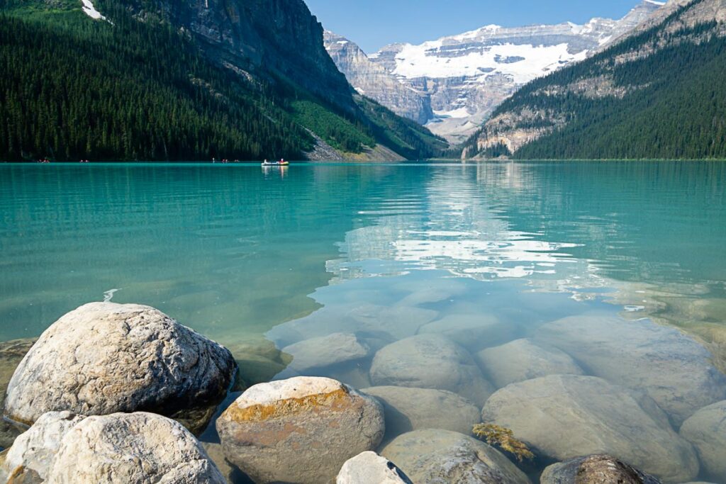
18. Plain of Six Glaciers Trail

Beginning as an easy stroll along the shoreline of the world-famous Lake Louise, the Plain of Six Glaciers trail is an incredibly scenic and rewarding hike. The trail then continues beyond Lake Louise and climbs into a stunning natural mountain amphitheatre.
Be sure to stop at the Plain of Six Glaciers Tea House to marvel at the Lake Louise glaciers while enjoying some coffee and chocolate cake.
19. Saddleback Pass Hike

The Saddleback Pass hike winds its way from the turquoise shores of Lake Louise, up the forested northern slopes of Fairview Mountain to a beautiful open meadow with spectacular views.
If you are visiting Banff in September and are able to time it right (late September), the Saddleback Mountain hike is also an excellent opportunity to walk through golden larch trees.
20. Sheol Valley Hike
Distance: The one-way distance of the Sheol Valley hiking trail is 4.1 km.
Elevation Gain: All downhill
Blog Post: Sheol Valley Hike

The Sheol Valley hike leads you through some spectacular Rocky Mountain scenery. What else would you expect from a Lake Louise valley created in the space between the majestic foursome of Fairview Mountain, Haddo Peak, Saddle Mountain and Sheol Mountain?
In addition to hiking in the shadow of these Lake Louise mountain peaks, you’ll be treated to towering mountain waterfalls, a hike along a mountain stream and, in season, a great opportunity to hike among larch trees without the massive crowds.
21. Fairview Lookout Hike
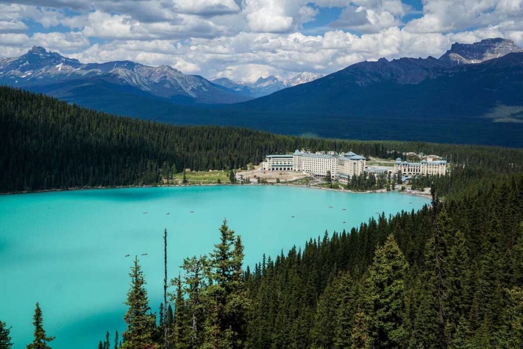
The Fairview Lookout hike is uphill the entire way, but don’t let that scare you, it’s quite short. At the end, you have phenomenal views looking down on Lake Louise and the Fairmont Chateau Lake Louise. If you want views down on Lake Louise but don’t have the time for longer hiking trails like the Big Beehive, this is a great alternative!
22. Lake Agnes Tea House Hike

The Lake Agnes Tea House hike is one of the most popular of the short Lake Louise hikes in Banff National Park. An easy hike up a mountain slope on the north side of Lake Louise, hikers will be rewarded with stops at two stunning mountain lakes: Mirror Lake and Lake Agnes.
A fun tradition is to reward yourself with a treat from the iconic Lake Agnes Tea House.
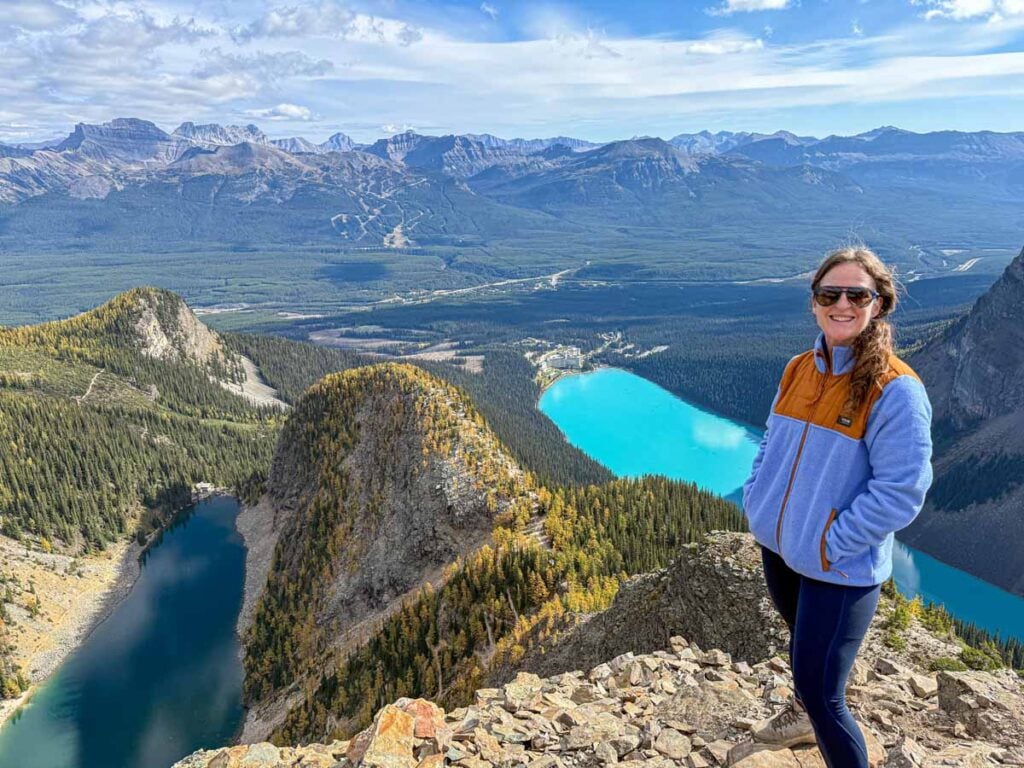
23. Big Beehive Trail

The Big Beehive hike in Lake Louise offers some truly incredible sights. If you have the time and energy after you hike to Lake Agnes, continue on the Big Beehive trail. You’ll enjoy some of the most incredible scenery in Banff by hiking the short, but sometimes steep, Big Beehive trail.
24. Little Beehive Trail

The Little Beehive hike at Lake Louise is accessed from the Lake Agnes trail. Once you have stopped and enjoyed a treat from the Lake Agnes Teahouse, you can enjoy some bonus Banff National Park scenery by adding on a short hike on the Little Beehive trail.
25. Devil’s Thumb Trail
The Devil’s Thumb hike is more of a scramble route than a hike, so you need to be confident in your abilities. To reach it, you’ll start from Lake Louise and hike up toward Lake Agnes before continuing beyond the Big Beehive area. Your reward will be incredible views of both famous lakes: Lake Louise and Lake Agnes.
There is no signage for the Devil’s Thumb Trail, but you’ll follow the Big Beehive trail to start. Make sure to read our blog post to find out where to start!
26. Mt St. Piran Trail

This trail follows the Little Beehive trail from Lake Agnes. You’ll enjoy even more incredible scenery on this Lake Louise hike! Watch for a faded Parks Canada sign that leads you to turn left about 500 m in on the Little Beehive trail.
Moraine Lake Hikes Without a Car
Moraine Lake has some of the most rewarding hiking in Banff National Park, but it also takes the most planning since you can’t drive there in a personal vehicle. With a Parks Canada shuttle, Roam Super Pass or commercial shuttle, you can still access some of the Best Hikes in Moraine Lake, including Consolation Lakes, Larch Valley, Sentinel Pass and Eiffel Lake.
These trails range from manageable half-day hikes to more challenging routes with serious elevation gain, so it’s worth choosing carefully based on your time, fitness and shuttle schedule. If you’re planning a longer hike from Moraine Lake, be sure to leave yourself enough buffer so you’re not rushing back for your return shuttle.
If you wish to visit Moraine Lake, our post on How to Visit Moraine Lake is a must-read.

How to get to Moraine Lake without a car:
- Shuttle: The Parks Canada Moraine Lake shuttle leaves from the Lake Louise Ski Resort Park & Ride to Moraine Lake (advance tickets required). Even if you have a Lake Louise Shuttle ticket you can take the Lake Connector shuttle to Moraine Lake (included in your ticket).
- Bus: When Moraine Lake is open you can take the Lake Louise 8X route to Lake Louise then get on the Lake Connector Shuttle if you purchase a Roam Super Pass.
Also Roam Super Pass holders can also take the Lake Connector shuttle for free. A Super Pass costs $30 for adults (compared to the $12.50 each way fare for the Lake Louise bus routes 8X) and allows you to ride any and all Roam Routes in a day. See more on Roam Transit Fares here. - Tour:
- Moraine Lake Big Bus Lake Shuttle stops at Moraine Lake, but it leaves from a hotel near Lake Louise.
- HopOnBanff bus runs June through September and makes a stop at Moraine Lake.
- Discover Banff Tours offers guided hikes to Larch Valley and Consolation Lakes.
- Moraine Lake Big Bus Lake Shuttle stops at Moraine Lake, but it leaves from a hotel near Lake Louise.
27. Consolation Lakes Trail
The beginning of the hike to Consolation Lakes has a bit of an uphill climb through a rock pile at the base of majestic Tower of Babel. You may need to step over an uneven rock or two in this section, but most people shouldn’t struggle with this.

This easy Banff hike ends along a very scenic spot along the shores of Babel Creek. Hikers who wish to reach the shoreline of the Consolation Lakes will need to do some minor scrambling for approximately 100 m over some medium-sized boulders. The boulders are a good spot to see marmots. Please help keep them wild by not feeding them.
28. Larch Valley Trail
Distance: 8.6 km out and back
Elevation Gain: 535 m
Blog Post: Larch Valley Hike
Related: Best Larch Tree Hikes in Alberta

The Larch Valley hike is the most famous larch tree hike in Lake Louise. It’s a bit of an effort to climb from Moraine Lake up the lower slopes of Mount Temple to get to Larch Valley, but the payoff is worth it, no matter the time of year. The stunning Valley of the Ten Peaks views you’ll earn on this trail are a big reason why Larch Valley is one of the best Banff National Park hikes.
Don’t think you should only hike to Larch Valley in September. In the spring and summer, you’ll love the views of the incredible mountains surrounding Moraine Lake as you walk through the pleasant larch forest.
29. Sentinel Pass Trail

For many, the Larch Valley hike ends when they reach the Minnestimma Lakes, but if you still have the time and energy, the Sentinel Pass trail is an extremely fun and rewarding extension to the Larch Valley hike.
The Sentinel Pass trail winds its way up a steep mountain pass in-between Pinnacle Mountain (3,070 m) and Mount Temple (3,544 m). Standing at the Minnestimma Lakes at the bottom of Sentinel Pass, the hiking trail looks like a bolt of lightning – zigging and zagging up the side of these two majestic Lake Louise mountains.
30. Eiffel Lake Trail
The Eiffel Lake hike starts out on the same trail as Larch Valley. Watch for the signs where you’ll deviate from the trail and where it will get much quieter (especially hiking in fall). The hike eventually levels out and offers incredible views of the ten peaks.

Mt. Norquay Hikes and Activities Without a Car
Mt. Norquay is another good option for getting above the Banff townsite without needing a car, especially if you want mountain views close to town. With the seasonal Norquay shuttle, you can access hiking options like Cascade Amphitheatre and Stoney Lookout, or add a more adventurous activity like the Via Ferrata.
This area is best for visitors who want something a little less obvious than the main Banff townsite trails, but still relatively easy to reach. Be sure to check the current shuttle schedule before planning your hike, since service can vary by season.
How to get to Norquay Ski Resort without a car:
- Shuttle: From June to early-October, Norquay operates a free shuttle from Banff to Norquay. See the Mt. Norquay shuttle schedule for stops.
31. Cascade Amphitheatre Hike

The beginning of the Cascade Amphitheatre trail starts out easy, but don’t get too comfortable. You’ll be climbing soon enough! Once you pass over the bridge at the 40 Mile Creek (which offers some impressive views), you’ll start climbing up. Eventually, you’ll begin the switchbacks, but it will all be worth it when you enter the Cascade Amphitheatre!
32. Upper Stoney Trail

The Upper Stoney Trail is a short, reactively easy hike in Banff. Sure, the climb in the first half will get your heart pumping, but once you reach the top, it’s all downhill.
This hike is predominantly in the trees, but you will get some nice views of Cascade Mountain and down the valley at the top.
33. Via Ferrata
We understand that this isn’t a hike, but we love that you can enjoy this assisted climbing experience without needing a car. We felt it was worth including!
The Norquay chairlift offers some incredible views on your way up to the Via Ferrata!

What to Pack for Hiking in Banff Without a Car
It’s not easy to know what to pack for Banff National Park. As you are interested in doing some hiking during your visit, the best resources for you are our guide on what to wear for hiking in Banff and our essential hiking gear for Banff.
If you are new to hiking in the mountains, don’t miss our Banff hiking tips!
Getting to Banff National Park without a Car
For those traveling from Calgary, there are plenty of ways to get from Calgary to Banff without renting a car. For many, the easiest way is to take one of these Calgary Airport shuttles to Banff.
Once you have made your way to Banff, you’ll find more suggestions on how to get around the national park in our post on getting around Banff without a car. You’ll notice that most of the hikes below have public transportation routes or tours that leave from the town of Banff.
Do You Need a Banff Park Pass Without a Car?
It’s important to note that even if you are visiting Banff without a car, you still need a Banff Park Pass. While we recognize that it would be nearly impossible for Parks Canada to check everyone that comes to Banff for their Banff Park Pass, it is still required (even if you don’t drive into the park).
It’s very likely you’ll come to Banff and never get checked. Please keep in mind that the money from Banff passes goes back into Banff National Park and helps maintain the scenic parkways, trails, and day use areas we love so much!
We share all the details about the Banff National Park Pass here.
Wildlife Safety
When hiking in Banff National Park, you are responsible for your own safety. Before hitting the hiking trails, we highly recommend you read our Essential Banff Hiking Tips for information about bear safety, trail conditions, wildlife warnings and possible closures.
Where to Stay in Banff Without a Car
The best places to stay in Banff National Park when you are visiting without a car are centrally located accommodations that are close to the Banff High School Transit Hub.
If you are planning a trip to Banff without a car, getting the small details right can make a big difference in your trip. Staying at a convenient hotel is a big one. We list all the best hotels in Banff for visiting without a car here.
Support Human Created Content

Hi, we’re Dan & Celine Brewer, locals from just outside Banff National Park. Every article, itinerary, and recommendation we share is rooted in our real experiences and love for this place. If you’ve found our content helpful, please consider supporting us:
- Make a small donation: Your support directly fuels our work and keeps our stories genuine.
- Purchase a guide or itinerary: Essential tools that help plan your trip and support local creators at the same time.
- Book lodging or tours through our affiliate links: You pay the same price, but we earn a small commission that helps us keep producing content.
Thank you for valuing authentic, human-created content. Your support allows us to help even more Banff travellers!
Love our content? Sharing our post is the easiest way to support us!


Celine Brewer, a local Canmore resident, is the co-owner of Travel Banff Canada. She has a passion for being out in the mountains any time of year. In the summer, you'll often find her hiking or mountain biking. In the winter, she enjoys cross-country skiing, snowshoeing and winter hiking the most.
As much as she loves the mountains, she also loves travel! When she's not playing outdoors at home, she's either traveling the world with her husband and two kids or working on their other two travel sites: Family Can Travel and Baby Can Travel.