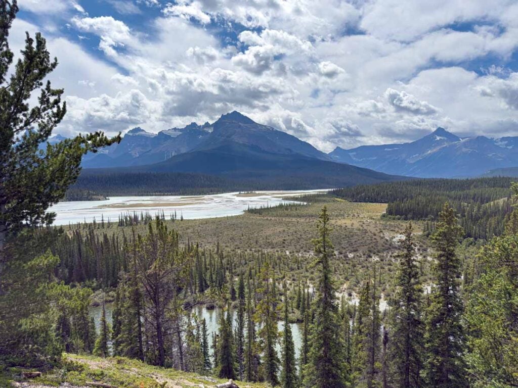
There is a reason people fly across the world to drive the Icefields Parkway; it’s one of the most scenic drives in the Canadian Rockies. This 232 kilometre drive between Lake Louise and Jasper strings together turquoise lakes, hanging glaciers, tumbling waterfalls, and wide valleys where elk and bighorn sheep still wander.
We have driven the Icefields Parkway many times, and I still am awestruck by the endless beauty of it. You can drive it in roughly three hours without stops, but the real magic happens when you slow down, pull over often, walk to the shoreline of a river or sit at a picnic table.
This complete Icefields Parkway guide shares the best stops, the important practical details, and personal tips that come from our experiences. If you have limited time and just want the highlights, start with our Top 10 Stops on the Icefields Parkway. If you have time to explore deeper, the Notable Stops section will help you build an itinerary that fits how you like to travel.

Where is the Icefields Parkway?
The Icefields Parkway is Highway 93 North. It connects Lake Louise in Banff National Park with the town of Jasper in Jasper National Park. The drive is part of the Canadian Rocky Mountain Parks UNESCO World Heritage Site, which speaks to just how much protected scenery you pass in a single day.
There is very little to no cell service once you leave Lake Louise and Jasper, so download an offline map and carry a paper map as backup. Services are limited, but you can find fuel and food at Saskatchewan River Crossing mid-route, and seasonal services at the Columbia Icefield area. Everything else is mountains, lakes, trailheads, and viewpoints.
You have a good chance to see wildlife on the Icefields Parkway. Give animals lots of space and use designated pullouts if you want to watch safely. Please obey the speed limits. They help protect wildlife and give you more time to react if the vehicle ahead of you stops suddenly for an animal sighting. The Icefields Parkway is one of the most scenic drives in the world – slow down and enjoy it!

Recommended App
If there’s one place you want to use the Guide Along App, it’s for the Icefields Parkway! This GPS activated Audio Driving Tour is the perfect companion for this drive. You’ll learn new things and see viewpoints you would have otherwise missed! Visit our Banff Discounts page for 15% off!

Read More
If you love this drive, be sure to check out our favourite scenic drives in Banff National Park for more beautiful routes to add to your trip.
How Long Does It Take to Drive the Icefields Parkway?
The Icefields Parkway is about 232 kilometres, which is 144 miles. Driving straight through with no stops takes roughly three hours. Most people take a full day because the scenery keeps pulling you over, and that is the point.
If you want to add some hiking or join the Columbia Icefield Adventure, we recommend you split the drive over two days. An overnight at Glacier View Lodge or The Saskatchewan River Crossing turns a long day into a more relaxed mini road trip.
If you are doing the very popular Calgary to Banff to Jasper and back circuit, you’ll naturally have two days to enjoy the Icefields Parkway, once in each direction. This strategy also allows you two full days of sightseeing on this very scenic drive through the Rockies.
Keep reading to see our suggested 1 and 2 day itineraries for the Icefields Parkway.

| TRAVEL BANFF CANADA
────────────── • ──────────────
Have so many Banff ideas…
but not sure how they fit together?
You can save every post, read every comment, and still not know what’s realistic in one day. The Banff & Jasper Planning Hub helps you connect the lakes, hikes, shuttles, scenic drives, restaurants, and Jasper days into one clear plan.
Workshops
Itineraries
Shuttle help
Restaurants
Discounts
Explore the Banff & Jasper Planning Hub
Top 10 Best Stops on the Icefields Parkway
Sorted in geographical order starting in the south near Lake Louise, these are the 10 best stops along the Icefields Parkway:
Bow Lake
Bow Lake is one of the first major highlights on the Icefields Parkway, and it’s worth slowing down for at least half an hour. The lake’s brilliant turquoise colour is framed by rugged mountains, with the Bow Glacier visible at the far right feeding into the lake. This is also the headwaters of the Bow River, which flows all the way through Banff and Calgary, and eventually into the Hudson Bay

There’s a short walk from the Bow Lake Lodge parking lot to the lakeshore, where you’ll find a few picnic tables. A lakeshore trail runs along the edge of the lake, giving you an easy hike at Bow Lake with quieter views away from the busy parking area.
Bow Lake is also the starting point for the classic Bow Glacier Falls hike (8.8 km return; 190 m gain); the route follows the lakeshore, then climbs to a roaring waterfall fed by the Wapta Icefield. The trail has been closed at the end of Bow Lake since June 2025, with no access to the falls. You can still enjoy the shoreline section of this hike, but check the Parks Canada trail report for updates before planning to go any further.
Facilities at Bow Lake include toilets, but like many popular stops along the parkway, Bow Lake can get very busy, so arrive as early as possible if you want to find a parking spot.
Peyto Lake
Peyto Lake is one of the most famous stops on the Icefields Parkway, and it’s easy to see why. From the viewpoint, the lake shines with an unreal turquoise colour created by glacial rock flour carried in from the Peyto Glacier. The viewpoint is also the highest point on the entire drive, which makes the sweeping mountain scenery even more impressive.
It is only a short, paved 600 metre walk from the parking lot to the viewing platform, which makes it accessible for most visitors. The outline of the lake is often compared to the shape of a wolf’s head, a detail that has made it a favourite among photographers.
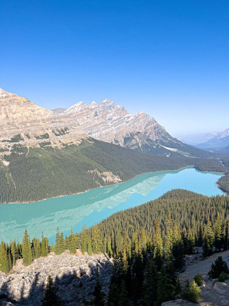
Like many top attractions along the Icefields Parkway, Peyto Lake gets very busy in summer. The best times to visit are early in the morning or later in the evening when the crowds have thinned and the light is softer.
If you have extra time, consider following the Bow Summit trail to reach additional viewpoints with even more elevated perspectives of Peyto Lake and Bow Lake. Even if you don’t do the Bow Summit trail, the lesser-known viewpoint over Peyto Lake is well worth it!
Read More
For more information on this iconic destination in Banff, check out our full post on visiting Peyto Lake.

Parker Ridge
If you only do one hike on the Icefields Parkway, make it Parker Ridge. This popular trail is a short but steady climb that rewards you with one of the best views in the Canadian Rockies.
")
The trail climbs about 250 metres / 820 feet over 2.7 km / 1.7 miles to a ridge overlooking the Saskatchewan Glacier, a massive tongue of ice that stretches down from the Columbia Icefield. The scenery is breathtaking, with sweeping views of glaciers, peaks, and valleys in every direction.
")
Most hikers take about 2 – 2.5 hours for the round trip, longer if you stop often for photos, which is hard to resist here. It is a busy trail in summer, but the views from the ridge make it all worthwhile.
Read More
For a deeper dive, check out our blog post on the Parker Ridge Trail.
Glacier Discovery Centre
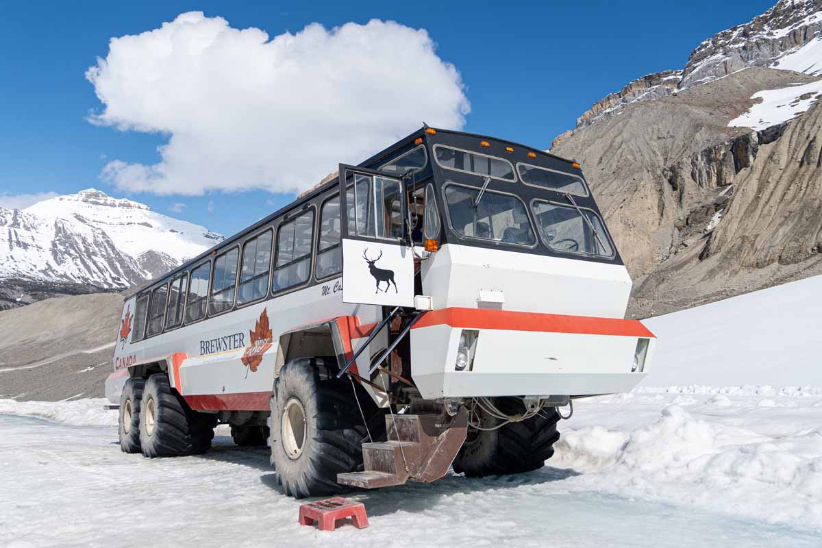
The Glacier Discovery Centre is the main hub of the Columbia Icefield and one of the best places to stop along the Icefields Parkway. It sits directly across from the Athabasca Glacier and has everything you need in one place. Inside you will find exhibits, a gift shop, places to eat including a Starbucks, and ticketing for the Columbia Icefield Adventure.
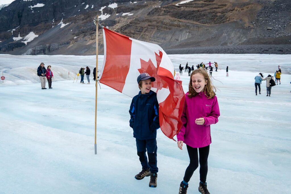
The highlight of the Glacier Discovery Centre is joining the Columbia Icefield Adventure, a 2.5 to 3 hour experience that combines two unique activities. First you board a massive Ice Explorer vehicle that takes you onto the Athabasca Glacier. Standing on the ancient ice, feeling the chill, and looking around at the surrounding peaks is an unforgettable experience.
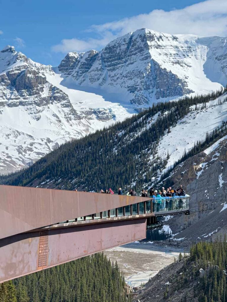
After the glacier, shuttles connect you to the Columbia Icefield Skywalk. This glass-floored platform sits 280 metres above the Sunwapta Valley and gives you incredible views of mountains, waterfalls, and hanging glaciers. Interpretive signs along the walkway explain the geology, wildlife, and Indigenous history of the region, making the visit both scenic and educational.
There is no public parking at the Columbia Icefield Skywalk. You must take a bus from the Glacier Discovery Centre.
You can book the Skywalk on it’s own, but we highly recommend the full Columbia Icefield Adventure, which includes the Skywalk.
Tangle Creek Falls
Just past the Columbia Icefield Skywalk, you’ll find Tangle Creek Falls, one of the most beautiful waterfalls along the Icefields Parkway. Although you can catch a glimpse from the highway, it’s worth pulling into the large parking lot and crossing at the marked pedestrian crosswalk for the best view.
Tangle Creek Falls is a spectacular multi-tiered waterfall. The upper tier is the widest, with several streams spilling down the vertical rock face before merging into a single flow. From there, the water cascades over the lower half of the falls in a series of drops that make it especially photogenic.

There are short trails leading up either side of the waterfall, giving you a chance to stand closer to the upper tier and appreciate its power. Facilities in the parking lot include toilets and garbage bins, and the views from here extend beyond the waterfall itself. Look across the valley and you can spot the Stutfield Glacier, as well as the massive icecap that covers the summit of Mount Kitchener.
Plan to spend 5 to 15 minutes here, longer if you enjoy photography or want to stretch your legs on the short trails. It is an easy stop that delivers big scenery with very little effort.
Directions to Tangle Creek Falls
Beauty Creek to Stanley Falls Hike
Just past Tangle Creek Falls, the Beauty Creek – Stanley Falls hike is one of the hidden gems of the Icefields Parkway. The trail starts from a small parking lot with room for about ten cars and follows Beauty Creek with Tangle Ridge towering overhead.

The path winds through forest and beside a narrow slot canyon where you will hear and then see a series of cascading waterfalls. It feels like a mix between Marble Canyon and Johnston Canyon, only without the crowds.
The trail ends at Stanley Falls, the tallest and most dramatic drop. The water plunges straight down in a freefall, and if you walk to the side you can see it dropping through open air. Plan about an hour for this rewarding stop.
Read More
We loved this hike so much, we wrote a full post about it. See more in our post on the Beauty Creek to Stanley Falls hike.
")
Sunwapta Falls
Sunwapta Falls is one of the must-see stops on the Icefields Parkway. The upper falls are just steps from the parking lot, where you can watch the Sunwapta River thunder through a narrow gorge and admire the view from the bridge above.

If you have more time, a 1.5 km / 0.9 mile one-way forest trail leads to the lower falls, a series of powerful cascades in a quieter setting. The walk is easy and offers beautiful river valley views along the way.
The main parking lot is large and has toilets and picnic tables, while nearby Sunwapta Lodge offers a gift shop and casual restaurant. Plan anywhere from 10 minutes to over an hour depending on how much you want to explore.
View the Sunwapta Falls Trail Map
Athabasca Falls
Athabasca Falls is one of the most powerful waterfalls on the Icefields Parkway and a stop you should not miss. Once you find parking at this busy site, take time to explore the many viewpoints.

You can see the falls from both sides of the river as well as from a bridge that crosses directly above the gorge. Each angle offers a different perspective on the sheer force of the water. Plan to walk all of the short paths to fully appreciate this impressive natural wonder.
Horseshoe Lake
Shaped like a horseshoe, this clear and calm lake quickly became one of our favourite surprises on the northern end of the Icefields Parkway.

A 1.6 km / 1 mile trail loops around the inner curve of the lake with great views of the water and surrounding mountains. It is also popular for paddle boarding and cliff jumping, although the parking lot is quite small. You will also start to see signs of the 2024 Jasper fire here, with the forest now starting to regenerate.
Valley of the Five Lakes
The Valley of the Five Lakes has long been one of our favourite hikes in Jasper. It really stands out for the way the trail winds past five small lakes, each with a slightly different shade of green and blue. The loop is about 4.5 km / 2.8 miles and is one of the best easy hikes in Jasper, which makes it a perfect stop for families.

The Valley of the Five Lakes trail is now open again after a lengthy closure due to the 2024 forest fire. It’s always a good idea to check the trail conditions before you go, but if it’s open, we recommend it as it is one of the most rewarding short hikes near Jasper.
View the Valley of the Five Lakes Trail Map

Let me Help with Your Banff Itinerary?
We have a suite of Banff Travel Planning services that can take all the guesswork out of planning your trip! Book a 1 hour travel consultation or let me create a custom Banff Itinerary for you!
Other Notable Stops Along the Icefields Parkway
Near Lake Louise and the South Parkway
Herbert Lake
The first stop on the Icefields Parkway is Herbert Lake, where you can enjoy a short walk to the shoreline and see stunning reflections of Mount Temple on calm mornings.
There is a medium-sized gravel parking lot with toilets, and most people spend just 5 to 10 minutes here before continuing north. Herbert Lake is also one of our favourite spots to go stand up paddleboarding in Banff.
Hector Lake
Hector Lake is the largest natural lake in Banff National Park, and while many travellers simply admire it from the road, there are short trails leading to the shoreline from three different pullouts. The third and final pullout offers the best views since there are fewer trees blocking the lake.
Directions to Hector Lake Lookout
Crowfoot Glacier Lookout
This large roadside viewpoint has space for more than 70 cars and gives you a great look at the Crowfoot Glacier, once shaped like three toes and now reduced to two due to melting. Parking can be hard to find because this lot often fills with hikers heading to Helen Lake.
Directions to Crowfoot Glacier Lookout

Helen Lake Hike
Helen Lake is one of the best moderate hikes along the Icefields Parkway, measuring 6 km / 3.7 miles one way. The trail climbs around Crystal Ridge with amazing views of Crowfoot Glacier and Bow Peak, before opening to expansive alpine meadows with endless mountain vistas.

Read More
Check out our full post on the Helen Lake hike.
Bow Lake Viewpoint
An alternative to the main Bow Lake stop, there is a roadside pullout where you can quickly stop and admire Bow Lake without walking down to the main lakeshore area. From here you will see the lake set against a dramatic mountain backdrop, but without views of the glacier.
Directions to Bow Lake Viewpoint

Mistaya Canyon
Mistaya Canyon is one of the hidden highlights of the Icefields Parkway. It is only a short ten-minute walk from the roadside parking area, yet it feels surprisingly wild once you reach the gorge. The Mistaya River has carved dramatic curves into the limestone, creating a narrow canyon with powerful rushing water that you can view from the sturdy bridge spanning the gorge.
What makes this stop so special is how easy it is to access while still feeling like an adventure. The short trail is a little steep and can be uneven, so good shoes are recommended. Once at the bridge, take time to wander along the rocks for different perspectives of the swirling water and canyon walls.
Mistaya Canyon is far less crowded than other Icefields Parkway stops like Peyto Lake or Athabasca Falls, which makes it a good choice if you want a quieter experience. Plan for about 20 to 30 minutes here, longer if you enjoy photography or simply want to sit and listen to the power of the river.
View the Mistaya Canyon Trail Map
Waterfowl Lakes Campground
There are two hikes that leave from the Waterfowl Lake Campground:
- Cirque Lake: This is a 9.2 km return forested trail to a glacier-view lake.
- Chephren Lake: This is an 8.2 km return gentle forest walk to a turquoise lake beneath Howse Peak and Mount Chephren.
Directions to the Waterfowl Lakes Campground

Waterfowl Lakes
This small parking lot fills quickly but turnover is fast, so it is usually possible to stop for a few minutes. The turquoise waters and surrounding peaks make Waterfowl Lakes one of the most scenic viewpoints along the Parkway.
Directions to the Waterfowl Lakes
Midway and Saskatchewan Crossing Region
Howse Pass Viewpoint
This fun little stop features a short semi-circular walkway with elevated views of the milky North Saskatchewan River and surrounding peaks. Interpretive signs explain the natural history of the valley, and the site has toilets, picnic tables, and a medium-sized parking lot.
Directions to Howse Pass Viewpoint
Saskatchewan River Crossing
Located where three rivers meet, Saskatchewan River Crossing is the only place with services on the Icefields Parkway. Here you will find a gas station, a small shop, and the Crossing Resort, which makes it an important stop even if it is not the most scenic one.
Directions to Saskatchewan River Crossing
Glacier Lake Trailhead
This trail begins just west of Saskatchewan Crossing and leads to Glacier Lake, the largest backcountry lake in Banff National Park. At 18 km / 11 miles return, it is a long but rewarding hike for those with extra time.
View the Glacier Lake Trail Map
Sunset Pass Trailhead
Across the highway from Glacier Lake, this trail climbs steeply toward Sunset Pass and Shimmer Lake. It is a strenuous backcountry route best suited for experienced hikers looking for solitude.
View the Sunset Pass Trail Map
Coleman Creek Day Use Area
A scenic picnic stop with plenty of tables and incredible mountain views in all directions. The North Saskatchewan River flows past here, and you may spot mountain goats on the cliffs across the highway. Toilets are available and the entrance is a proper left-hand turn lane.
Directions to Coleman Creek Picnic Area
")
Weeping Wall
Best seen when driving southbound on the Icefields Parkway, this roadside cliff face ‘weeps’ with dozens of thin waterfalls. Flow is strongest in spring, and by late summer the water is often reduced to a delicate curtain.
Directions to the Weeping Wall Viewpoint

Big Bend Viewpoint
Here the Icefields Parkway makes a dramatic curve as it climbs toward the Columbia Icefield. The viewpoint looks back on the winding highway and surrounding peaks, with Bridal Veil Falls tumbling down the mountainside in the distance. Note that the stop is only accessible when driving north.
Directions to the Big Bend Viewpoint

Panther Falls and Bridal Veil Falls
Shortly after the Big Bend Viewpoint, you’ll find another parking area on the right. This is where you can reach the lesser known Panther Falls and a closer viewpoint for Bridal Veil Falls (which you can see from the parking lot).
View the Panther Falls Trail Map

Nigel Creek Trailhead
This trail begins near the Big Bend Viewpoint and offers access to Nigel Pass and other backcountry routes. It is less traveled but rewards hikers with alpine meadows and views of distant peaks.
View the Nigel Creek Trail Map
Wilcox Pass Trailhead
Wilcox Pass is one of the most popular hikes in the Columbia Icefield area. The short trail climbs to open meadows with sweeping views of the Athabasca Glacier, and Parks Canada red chairs at the top provide the perfect spot to soak it all in. You can continue past the red chairs for closer views over the Athabasca Glacier.
")
Read More
We loved our hike to the Parks Canada red chairs on Wilcox Pass. For more details on this quick, scenic hike, check out our post on the Wilcox Pass Viewpoint Hike .

Toe of the Glacier Hike
Across the road from the Columbia Icefield Glacier Discovery Centre, this 1.5 km / 1 mile trail takes you as close as you can get to the Athabasca Glacier without booking a tour.
The steep first section passes year markers showing how far the glacier has retreated, and at the top you will feel a blast of cold air rolling off the ice. The trail ends at the glacier’s meltwater stream, the source of the Sunwapta River. Toilets are available at the parking lot.
View the Toe of the Glacier Trail Map

| TRAVEL BANFF CANADA
────────────── • ──────────────
Saved 27 Banff Posts…
and still not sure your itinerary works?
The problem isn’t a lack of information. It’s too much scattered advice. The Banff & Jasper Planning Hub helps you turn blog posts, shuttle info, Facebook tips, and itinerary ideas into one clear plan.
Workshops
Itineraries
Shuttle help
Restaurants
Discounts
Explore the Banff & Jasper Planning Hub
North Parkway Stops Near Jasper
Stutfield Glacier Viewpoint
This quick stop has a large parking lot and one of the best views of the dramatic Stutfield Glacier with the North Saskatchewan River in the foreground. Look closely and you will see several waterfalls pouring down the glacier. Facilities include toilets and a single picnic table.
Note, this pull-out has a “no left turn” sign, meaning it must be accessed driving southbound.
Directions to Stutfield Glacier Viewpoint

Honeymoon Lake
Honeymoon Lake is both a campground and a picnic area with toilets and picnic tables by the shore. It is a peaceful spot to enjoy views of the Endless Chain mountain range and is also popular for paddle boarding on calm days.
Goats and Glaciers Lookout
This day-use area is known for attracting mountain goats, who come down to lick the mineral-rich soil near the Sunwapta River. Even if the goats are not around, the views of the river and mountains make it worth a short stop. Toilets and picnic tables are available.
Directions to Goats and Glaciers Lookout

Athabasca Pass Viewpoint
This large pullout has sweeping views down the river valley towards the Columbia Icefield, with Whirlpool Mountain dominating the view. You can also clearly see areas affected by the 2024 Jasper fire, a sobering reminder of how destructive and powerful nature can be.
Directions to Athabasca Pass Viewpoint
Wabasso Lake
This small subalpine lake is a quiet alternative to Jasper’s busier lakes, with a trail leading around its shoreline.
View the Wabasso Lake Trail Map
Wildlife on the Icefields Parkway
Wildlife sightings are common along the Parkway. You might see elk in the valleys, bighorn sheep on the cliffs, mountain goats near mineral licks, and the occasional black bear or grizzly in the spring and early summer. Dawn and dusk are the most active times, although we have been surprised in the middle of the day too.
Watch from the safety of your vehicle or from a proper pullout. Keep food stored, keep pets leashed, and never approach or feed wildlife. If you are hiking, make noise on the trail, carry bear spray and know how to use it. In autumn you may hear elk bugling near Jasper, which is a beautiful sound, but give them plenty of room during the rut.
Where to Stay on the Icefields Parkway
If you’d like to spend a night or two on or near the Icefields Parkway, you have two main approaches. You can base yourself in the towns of Banff, Lake Louise and/or Jasper and day trip the Parkway, or stay overnight at a lodge or campground along the route. Both work well, and it depends on your pace.
Town Bases
- Lake Louise is perfect for an early start northbound.
- Jasper works well if you are coming from the north and want to save the waterfalls and lakes near town for the afternoon or the next morning.
- Banff is a little farther south, but it is an easy hop to Lake Louise to begin your drive.
Read More
Don’t book your Banff accommodation without reading our guides to the best hotels in Banff and the best hotels in Lake Louise.
En Route Stays
- Glacier View Lodge sits opposite the Athabasca Glacier. Waking up to that view makes the whole trip feel special.
- The Crossing Resort at Saskatchewan River Crossing is the practical middle point with fuel and a shop.
- Sunwapta Falls Rocky Mountain Lodge, a cozy cabin-style base on the Icefields Parkway a short walk from the falls, with comfortable rooms and a handy on-site restaurant.
- Campgrounds open seasonally along the Parkway and near Jasper. Options commonly include Waterfowl, Rampart Creek, Wilcox Creek, Honeymoon Lake, Wapiti, and others near Jasper. Check current conditions and openings, especially after the 2024 fire in Jasper National Park, since some areas and trails are still in recovery.
Booking early is smart for summer, especially if you want glacier-view rooms or specific campground dates. If everything on route is full, stay in Lake Louise or Jasper and treat the Parkway as a long day with a clear plan.
Where We Stayed
On our most recent visit to the Icefields Parkway, we stayed two nights at the Glacier View Lodge. Given its central location on the parkway, it was the perfect place to base our adventures! For more information, read our Glacier View Lodge review.
Driving Tips for the Icefields Parkway
Best Time of Year
Late June through September brings long daylight, open facilities, and the widest choice of hikes. May and October can be beautiful with fewer people, but weather is variable, some trails can hold snow, and services are limited. Winter travel is possible for experienced drivers with proper tires (November 1 to April 1) and a flexible plan, although closures and avalanche control can affect timing.
Fuel and Food
Fuel is available in Lake Louise and Jasper, and mid-route at Saskatchewan River Crossing (although very expensive). Food and washrooms are available at the Crossing and seasonally at the Columbia Icefield area. Carry snacks and water, especially if you plan to hike.
Road Safety
Use the many pullouts for photos. Watch for wildlife on the shoulder. Carry layers, even in summer. Mountain weather changes quickly, and it is often cooler and windier near the glaciers.
Navigation and connectivity
Download your road maps and trail maps before you go as there is very little cell coverage on most of the route. Tell someone your plan if you are hiking, then stick to it.

Icefields Parkway Tours If You Don’t Want to Drive
There are several ways to experience the Parkway without doing the driving. Some guided tours cover the full route, while others run from Banff or Jasper to the Columbia Icefield and back. These tours include the Columbia Icefield Adventure and Skywalk, with photo stops at the classic viewpoints. This is a good option for visitors who prefer to relax, for winter travel, or for anyone who simply wants to let someone else manage the logistics.
If you plan to travel car-free, a guided tour is the most convenient way to see the Parkway in a single day. If you are based in Banff or Jasper and don’t have the time to see the full Icefields Parkway, you can also book a tour which takes you from your base town to the Columbia Icefield and back.

Recommended Tour
Radventures Canada is one of the top-rated, small group tours for the Icefields Parkway that includes the Columbia Icefield Adventure. See our Banff discounts for 5% off!
Icefields Parkway Itineraries
Use these premade Icefields Parkway itineraries as a starting point for planning your own trip. The weather, the light, and how much you like to linger will all play a part in how your day actually goes.
One-Day Icefields Parkway Itinerary
- Start early in Lake Louise.
- Bow Lake for shoreline views and a quick lakeside walk.
- Peyto Lake for the classic turquoise panorama.
- Mistaya Canyon for a short walk to the bridge and swirling water below.
- Saskatchewan River Crossing for fuel, washrooms, and a snack.
- Parker Ridge hike if the weather is clear and you have two hours, or continue to the Columbia Icefield area.
- Columbia Icefield area for glacier views from the roadside, or the Toe of the Glacier short hike.
- Tangle Creek Falls for a quick waterfall stop.
- Sunwapta Falls, then Athabasca Falls near Jasper to finish strong.
This one-day Icefields Parkway itinerary fits in a full day with short walks and photo stops. If you prefer a seated break, trade one of the hikes for the Columbia Icefield Adventure and Skywalk (advance reservations highly recommended).

Two-Day Icefields Parkway Itinerary
Day 1
- Lake Louise start, then Bow Lake and Peyto Lake.
- Mistaya Canyon.
- Saskatchewan River Crossing for lunch.
- Parker Ridge hike in the afternoon for Saskatchewan Glacier views.
- Check in at Glacier View Lodge. Enjoy quiet glacier views once the day trippers have gone.
Day 2
- Morning at the Columbia Icefield. Book the Columbia Icefield Adventure and Skywalk, or walk the Toe of the Glacier trail.
- Tangle Creek Falls.
- Beauty Creek to Stanley Falls short hike for a string of waterfalls in a narrow canyon.
- Sunwapta Falls, then Athabasca Falls near Jasper.
- Roll into Jasper for dinner.

FAQs about the Icefields Parkway
Do I need a park pass to drive the Icefields Parkway?
Yes. The entire route is inside Banff and Jasper National Parks. You can buy a Parks Canada pass online or at the park gates and visitor centres.
Is the Icefields Parkway open year-round?
Yes, although winter conditions can be severe and short-notice closures can occur for avalanche control or weather. Always check weather and road conditions before you go and travel with proper tires and a flexible plan in winter. Requirements for the Icefields Parkway are tires with the snowflake symbol or M+S (mud + snow) symbol starting from November 1 to April 1 every year.
Which direction is better, Jasper to Lake Louise or the reverse?
That’s nearly impossible to say, as both directions are beautiful. Starting in Lake Louise lets you reach Bow Lake and the Peyto Lake viewpoint earlier and puts the Columbia Icefield near midday. Starting in Jasper gives you Athabasca Falls and Sunwapta Falls earlier in the day, then big glacier views as you head south.
How long does it take to drive the Icefields Parkway?
Three hours without stops. A full day is more realistic. Add a night on route if you want to hike Parker Ridge or Wilcox Pass or if you want to join the Columbia Icefield Adventure.
Where can I find fuel and food along the way?
Fuel is only available in Lake Louise, at Saskatchewan River Crossing, and in Jasper. Food and washrooms are available at the Crossing and seasonally at the Columbia Icefield area.
Is there cell service on the Icefields Parkway?
Very little. Plan to be offline for most of the drive and download maps in advance.
Are drones allowed?
Recreational drones are not permitted in national parks in Canada without a special permit. This is strictly enforced – leave your drone at home.
Can I swim or paddle in the lakes along the Parkway?
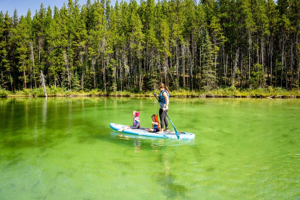
Yes in some locations when conditions are safe, although the water is very cold. Always follow posted signs and any clean-drain-dry regulations for Banff and Jasper National Park. A popular flatwater option on calm days is Horseshoe Lake.
Are pets allowed at viewpoints and on trails?
Yes, if they are leashed. Keep dogs close and under control, and pack out waste.
What about closures after the 2024 Jasper fire?
Some trails and areas remain affected. Check the current Jasper trail report and any area closures for Jasper National Park before you go, and have a backup plan.
Do I need four-wheel drive for the Icefields Parkway?
No. The Parkway is a paved highway. In winter you need proper winter tires and winter driving experience, not necessarily four-wheel drive. Requirements for the Icefields Parkway are tires with the snowflake symbol or M+S (mud + snow) symbol. This starts November 1 to April 1 every year. Learn more here.
Are there bathrooms along the route?
Yes, nearly all the stops discussed in this post have toilets. You will also find facilities at Saskatchewan River Crossing and the Columbia Icefield area.

Final Thoughts: Why the Icefields Parkway Belongs on Your Bucket List
The Icefields Parkway is a once-in-a-lifetime road trip. It invites you to slow down, get out of the car, and feel small in the best possible way. Plan your day, bring snacks, and be ready to change course when you see something beautiful.
If you want a done-for-you plan that maps the right stops to your timing, my prebuilt itineraries and travel consultations will save you hours and make the day smoother. However you choose to do it, give the Icefields Parkway the time it deserves. You will remember this one.
Let me Help with Your Banff Itinerary?
We have a suite of Banff Travel Planning services that can take all the guesswork out of planning your trip! Book a 1 hour travel consultation or let me create a custom Banff Itinerary for you!
")
Support Human Created Content

Hi, we’re Dan & Celine Brewer, locals from just outside Banff National Park. Every article, itinerary, and recommendation we share is rooted in our real experiences and love for this place. If you’ve found our content helpful, please consider supporting us:
- Make a small donation: Your support directly fuels our work and keeps our stories genuine.
- Purchase a guide or itinerary: Essential tools that help plan your trip and support local creators at the same time.
- Book lodging or tours through our affiliate links: You pay the same price, but we earn a small commission that helps us keep producing content.
Thank you for valuing authentic, human-created content. Your support allows us to help even more Banff travellers!

Dan Brewer, a life-long Alberta resident, calls Canmore home along with his wife and two kids. He is the co-owner of Travel Banff Canada, where he gets to share his passion for the Canadian Rocky Mountains. Dan, along with his family, love being outdoors doing one of the many activities they enjoy in the mountains: hiking, mountain biking, paddleboarding, skiing, snowshoeing and cross-country skiing.
When he's not in Canmore enjoying one of his favourite local hikes, you can find him hopping on a plane to explore a new country with his family or working on one of their other two travel sites: Family Can Travel and Baby Can Travel.