For experienced hikers who are comfortable with exposure, the Tent Ridge Horseshoe Trail is one of the best hikes in Kananaskis Country, and perhaps in all of the Canadian Rockies. With an amazing location near the southern end of the Spray Lakes, the horseshoe-shaped Tent Ridge hike provides experienced hikers a wide variety of epic mountain vistas.
Due to the incredible scenery, the Tent Ridge Horseshoe hike has received a lot of social media attention recently and has exploded into one of the most popular hikes in Kananaskis Country. But the Tent Ridge hike is quite challenging, and is certainly not for everyone…
This post contains compensated links.
Is the Tent Ridge Trail Right For You?
How Long is the Tent Ridge Trail?
The Tent Ridge Horseshoe Trail is about 10.5 km / 6.5 miles long as a loop. It’s a manageable distance for a strong hiker, but be aware that this is a bigger hiking day than the distance alone might suggest.
How Steep is the Tent Ridge Trail?
The Tent Ridge Horseshoe Hike has about 843 m / 2,765 ft of elevation gain, with an extended steep climb to gain the ridge. The uphill sections are sustained, and the loose gravel and shale can make both the climb and descent more tiring than a typical Kananaskis hiking trail.
How Hard is the Tent Ridge Hike?
Tent Ridge is a challenging Kananaskis hike and best suited to confident hikers who are comfortable with exposure, loose terrain and a few short scramble sections. The ridge views are well worth it, but this is not a good choice for anyone nervous around drop-offs or looking for a casual Kananaskis walk.
Of all the difficult hikes in Kananaskis Country, Tent Ridge seems to attract the highest number of hikers who may not be fully prepared for the terrain. This is worth taking seriously, because it’s not just a hard hike. It has loose sections, short scrambles and exposed ridge terrain where being uncomfortable, underprepared or inexperienced can quickly become a real safety concern.
How Long Does It Take to Hike Tent Ridge?
Most hikers should plan on about 5 to 6 hours for the full Tent Ridge Horseshoe hike, especially if you want time to enjoy the ridge and take photos. Strong, fast hikers may finish more quickly, but we recommend leaving extra time so you do not rush on the steeper or more exposed sections.
The last two times we hiked the Tent Ridge Horseshoe Trail, it took us between 3.5 – 4.5 hours.
Alternatives to the Tent Ridge Horseshoe Hike
If the Tent Ridge hike isn’t right for you, don’t worry as there are plenty of excellent hikes in Kananaskis Country for all skill levels.
If you are looking for something a little easier, there are several excellent moderate Kananaskis hikes nearby. The Karst Spring Trail is just a few minutes away and features one of the most spectacular waterfalls in the Canadian Rockies!
Another solid alternative to hiking Tent Ridge is the Chester Lake Trail. Just 10 minutes away from the Tent Ridge trailhead, the Chester Lake Trail is one of my very favourite hikes in Kananaskis Country due to its outstanding scenery-to-effort ratio.
| TRAVEL BANFF CANADA
────────────── • ──────────────
Have so many Banff ideas…
but not sure how they fit together?
You can save every post, read every comment, and still not know what’s realistic in one day. The Banff & Jasper Planning Hub helps you connect the lakes, hikes, shuttles, scenic drives, restaurants, and Jasper days into one clear plan.
Workshops
Itineraries
Shuttle help
Restaurants
Discounts
Explore the Banff & Jasper Planning Hub
Tent Ridge Trail Highlights
Hiking the Tent Ridge Horseshoe Trail Clockwise
The Tent Ridge Horseshoe Trail is a full loop hiking trail, so you have the option of going clockwise or counter-clockwise. The most popular direction to hike Tent Ridge is clockwise, so that is the direction we always hike it and will describe in this post.
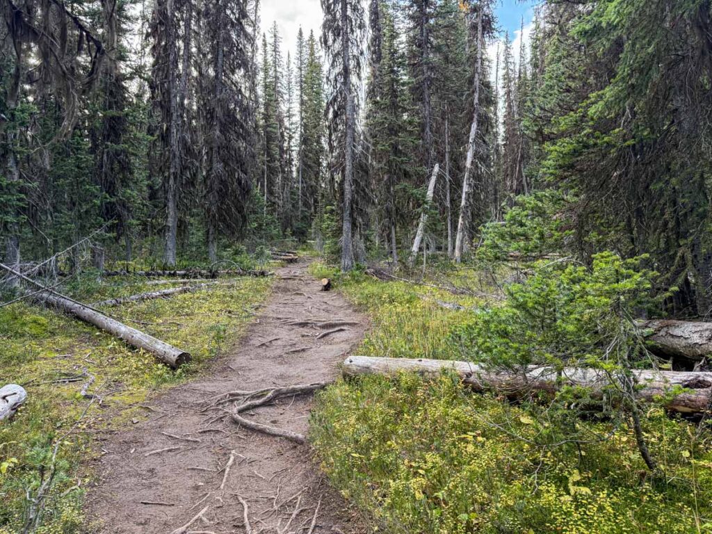
Starting the Tent Ridge Trail Through the Forest
It’s a short walk on a gravel road from the parking lot to where the Tent Ridge trailhead is. As you enter the wide path into the trees, it gets steep almost immediately.
There are a few tricky trail junctions along the first leg of the Tent Ridge Trail that you need to be careful with. The first is at 800 m (2,600 feet) where you will see a trail going left. It usually has a bunch of fallen trees over it, signalling you to continue right.
The trail continues to climb at the 1 km (0.6 mile) mark. If you need to catch your breath, there are occasional breaks in the trees where you can enjoy views of the Spray Lakes, Mt. Nester and Mt. Engadine too.
Reaching the First Views of the Tent Ridge Horseshoe
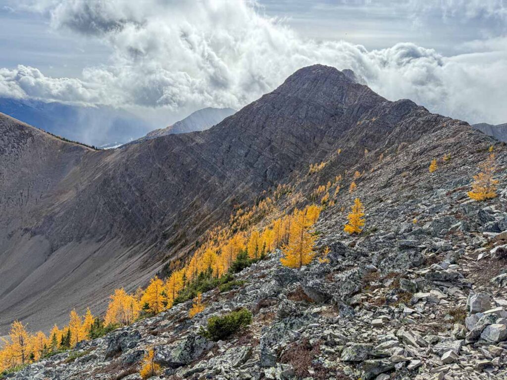
After 2.1 km (1.3 miles) of primarily hiking through evergreen forest, the Tent Ridge Trail enters a clearing. You get good views of the horseshoe-shaped Tent Ridge from here, including the large forest of larch trees which grows on its slopes.
In fall, the needles on the larch trees turn golden yellow, one of the most beautiful sights in the Rockies. For more on this, check out our post on the best larch tree hikes in Alberta.
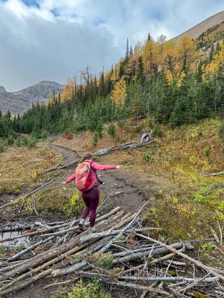
Beyond the clearing, the forest along the hiking trail is much thinner now, with smaller trees. You cross a small creek over a makeshift bridge made of skinny fallen trees. Again, a great view of Tent Ridge lies ahead. It’s hard not to be intimidated from this vantage point, looking at how high it goes up the rocky slopes.
At the 2.5 km (1.6 mile) mark, you’re nearing the belly of the horseshoe-shaped Tent Ridge.
When we hiked Tent Ridge in early October, the massive forest of larch trees on the righthand slope was glowing yellow. The larch forest you walk through is nice, but it’s the distant views of the larches that are the star of the show.
200 m later, you enter a full clearing with the best view of the horseshoe that you will get. From here you can see the full 270° of Tent Ridge on display in front of you. It’s a breathtaking sight and I got very excited for the adventure to come.
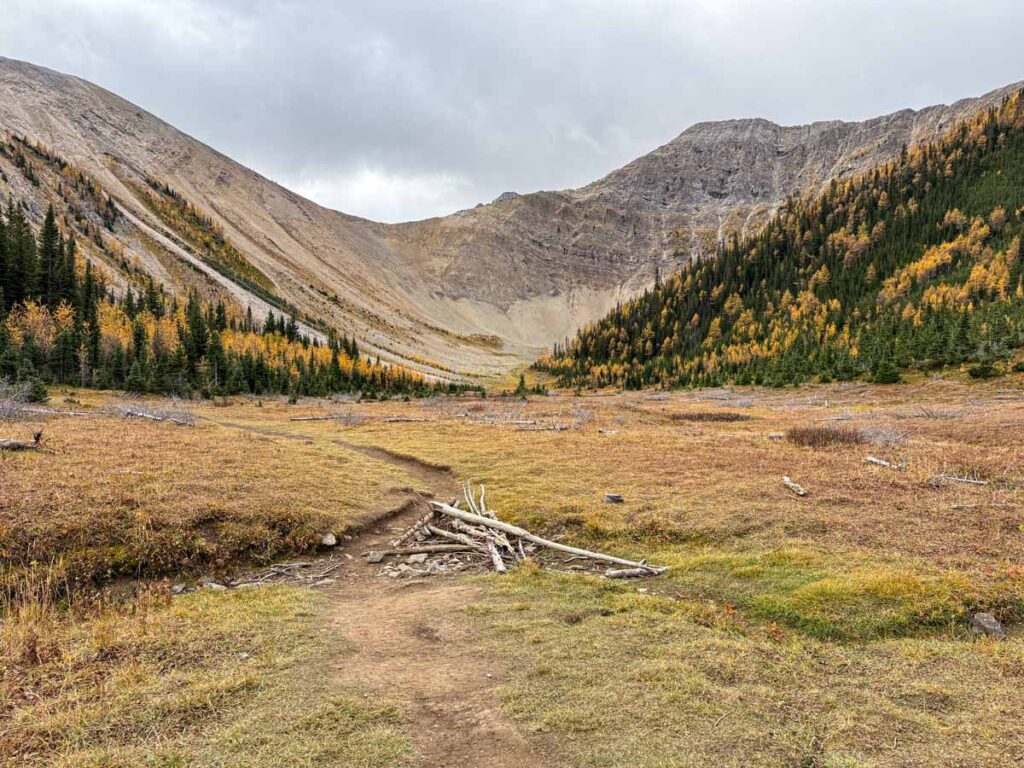
Beyond the clearing, you’ll re-enter the forest one last time. Then, suddenly you’ll see a tall pyramid shaped rocky hill in front of you through the trees. This is where the adventure really begins!
Climbing the Steep Eastern Side of Tent Ridge
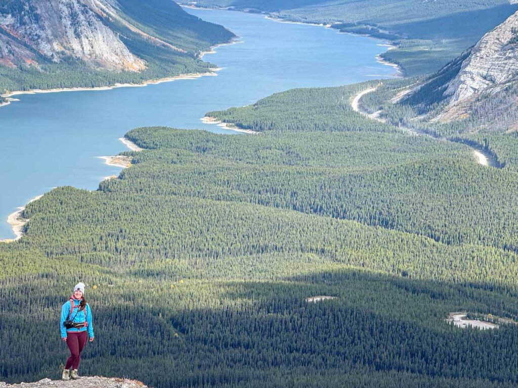
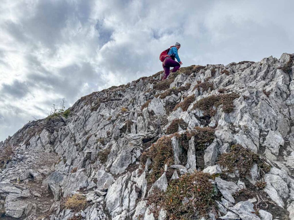
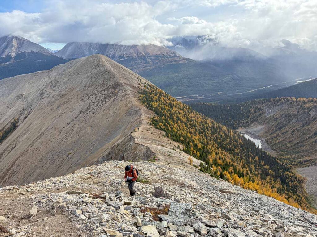
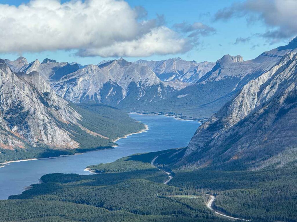
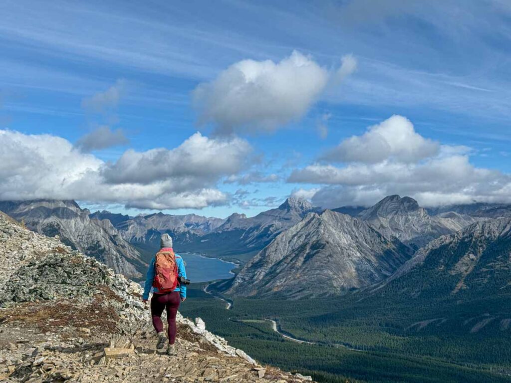
Leaving the forest, you begin the very steep ascent up the rocky slopes of Tent Ridge. It’s hard work, but without tree cover the views of the mountains down the valley are amazing. Even from down here, you can see from Mount Engadine all the way down to Mount Galatea and beyond. A little further up the trail, Spray Lakes Reservoir appears, giving just the first of many outstanding views of the lake.
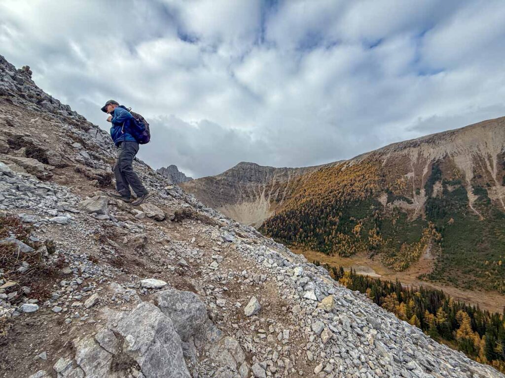
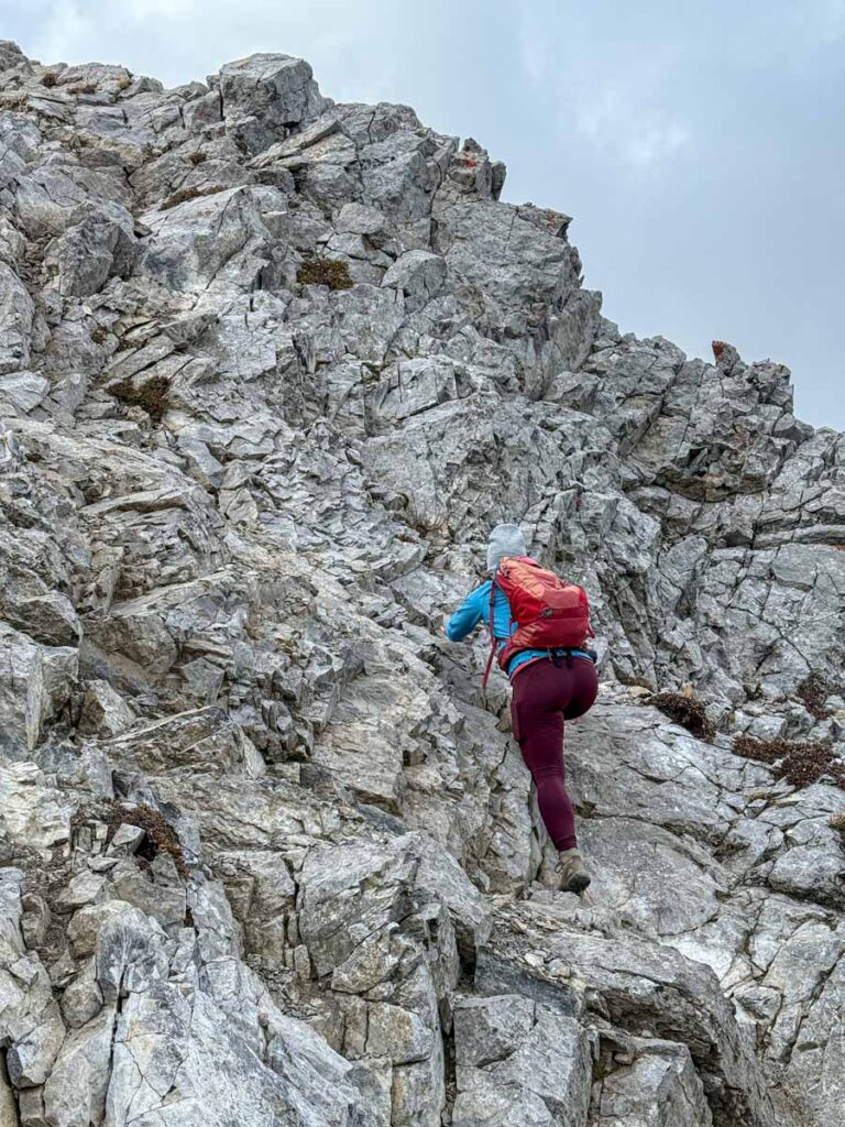
The hike up this portion of the Tent Ridge Trail is very steep, with many tight S-curve switchbacks to negotiate. Just when you are settling into the tight switchbacks, you’ll encounter your first scramble. Although it wasn’t very busy that day, we encountered a bit of a log jam here as hikers slowly and carefully negotiated the precarious rock scramble. I’m not a big fan of heights, so I too took as much time as I needed to get through this dangerous section of Tent Ridge.
After a few short scrambles, you’ll reach the lower shoulder of Tent Ridge. This is a popular spot to stop and rest, have a snack, make any necessary wardrobe changes and soak in the incredible Kananaskis Country views.
Hiking the Exposed Ridge to the Tent Ridge Weather Station
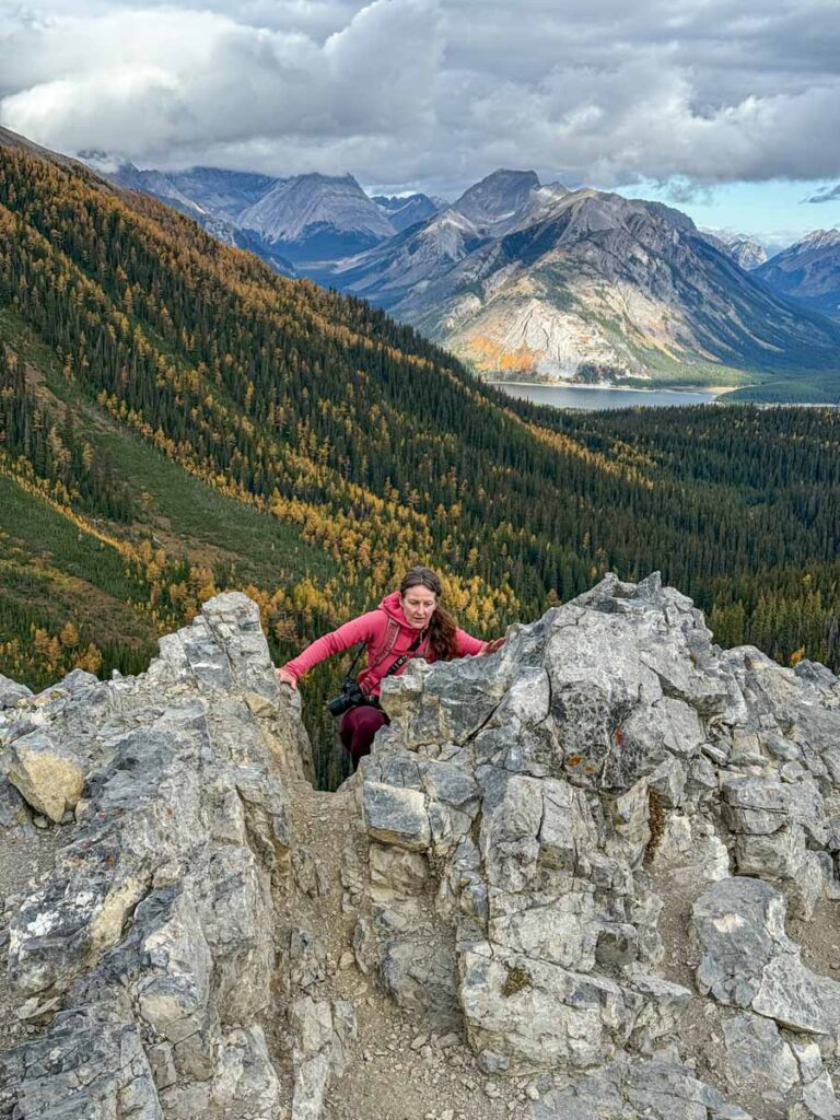
Leaving the clearing behind, there are several more steep, dangerous scramble sections ahead. These sections are for experienced hikers only and should not be attempted by those not familiar with alpine mountain hiking.
Once you pass the next few scramble sections, take a minute to look behind you at what all your efforts have earned you so far. From here you can see nearly all the way up the Spray Lakes Reservoir, and further down the Smith-Dorrien Trail towards the Hogarth Lakes. It really feels like you can see forever, and you still have a ways to go until you reach the true summit of Tent Ridge.
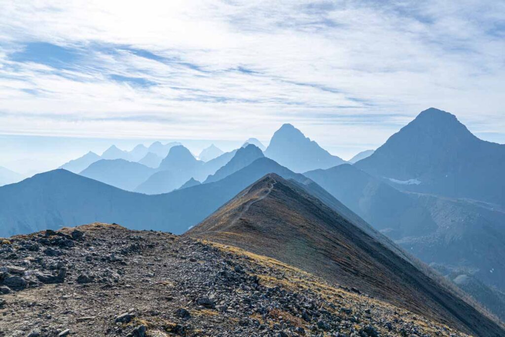
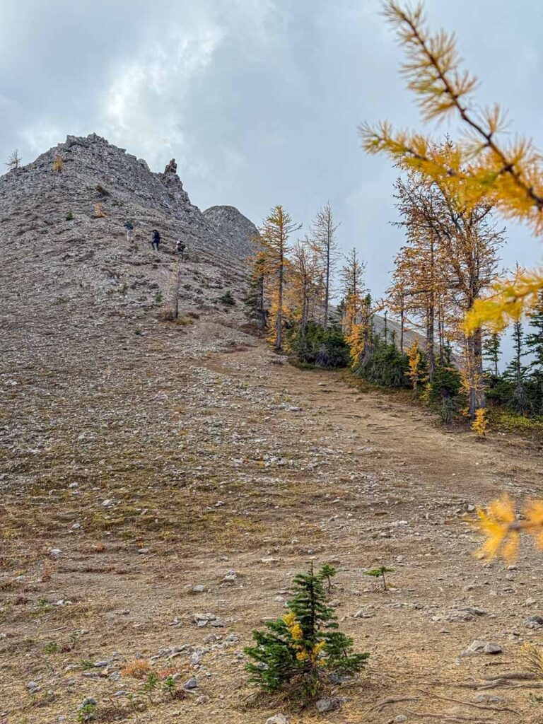
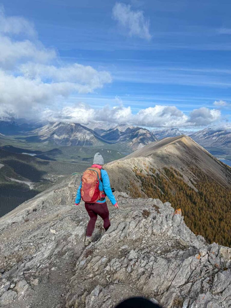
This hiking trail is called Tent Ridge for a reason, as so much of the hiking trail above the alpine zone follows a ridge. I love hiking on ridges as you get views looking down on both sides. Here, you have an especially enjoyable section of ridge hiking to enjoy before you reach the last scramble.
The final scramble is my least favourite of the bunch (I don’t do well with drop-offs). It’s a short scramble, but the exposure is real and there are some serious consequences for any missteps.
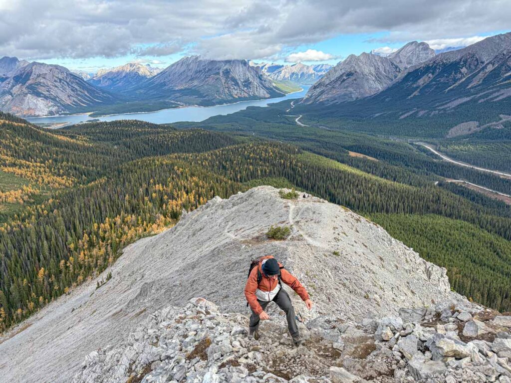
After the final scramble it’s a hike along some rocky scree on a ridge all the way to the weather station. It’s steep uphill again with more tight S-curve switchbacks.
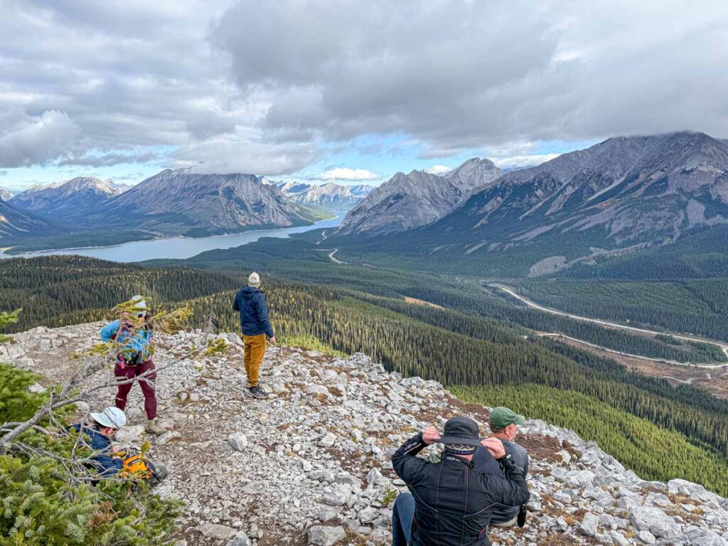
Once at the weather station, take a moment to stop and enjoy. As with the shoulder below, the Tent Ridge Weather Station is another popular spot to stop, rest and soak in the seemingly endless Rocky Mountain views in every direction.
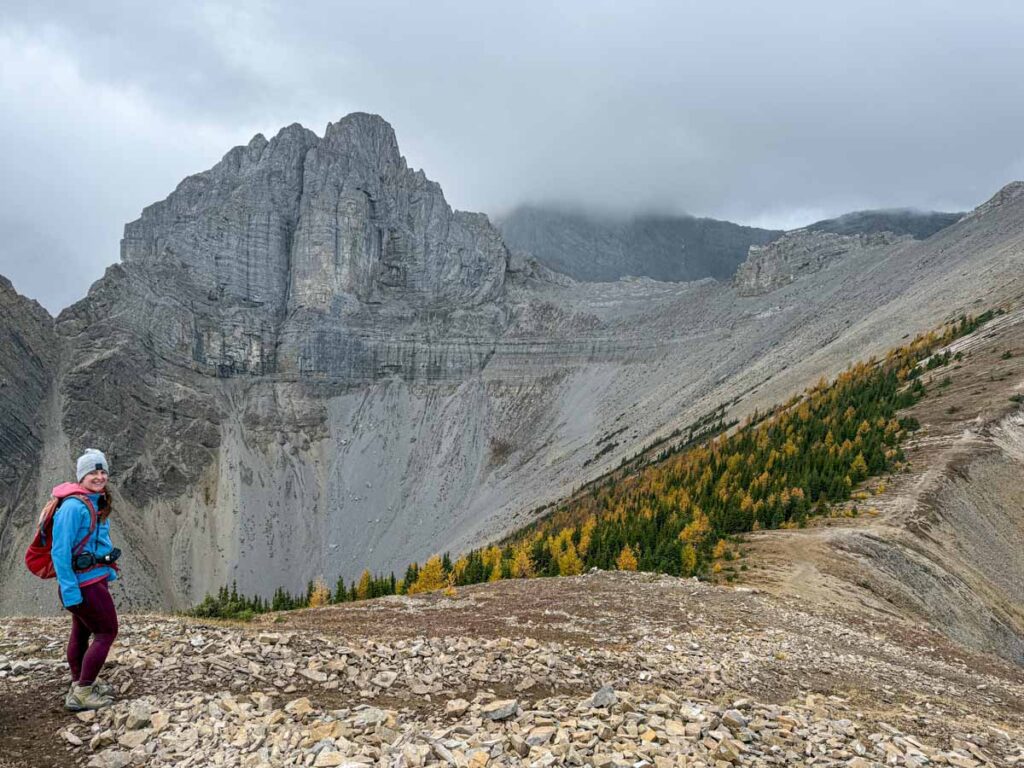
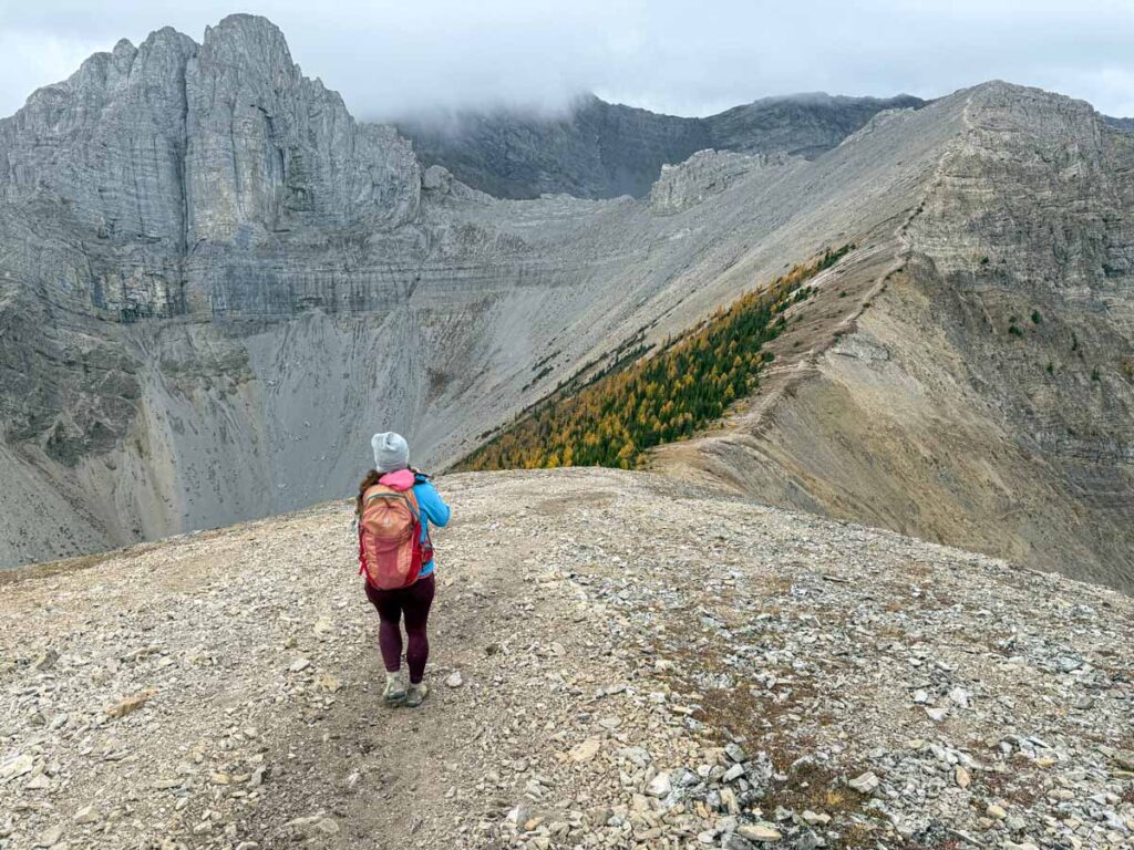
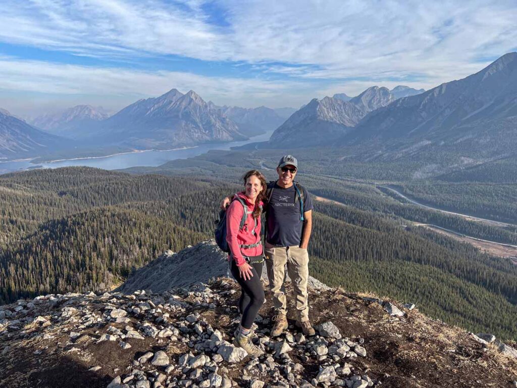
From the weather station, it opens up views to the south, where one of the most dramatic mountains in the region can be seen. Towering over you is the majestic mountain called “The Fist” (2,630 m), the perfect name for such a powerful mountain. Below The Fist is yet another larch forest and a small lake called Tryst Lake.
Despite the world-class mountain views, we didn’t stay for long, as it started to snow on us (as sometimes happens during larch season in early October).
Hiking From the Weather Station to the True Summit of Tent Ridge
The Tent Ridge Weather Station feels like the highest point on the Tent Ridge hike, but it’s not. First you need to descend to a pass at the very top of the horseshoe, then you need to climb back up to the true summit of Tent Ridge.
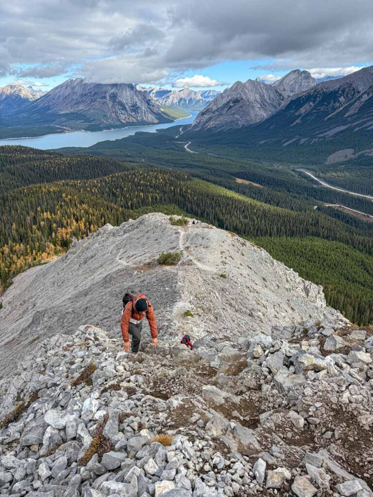
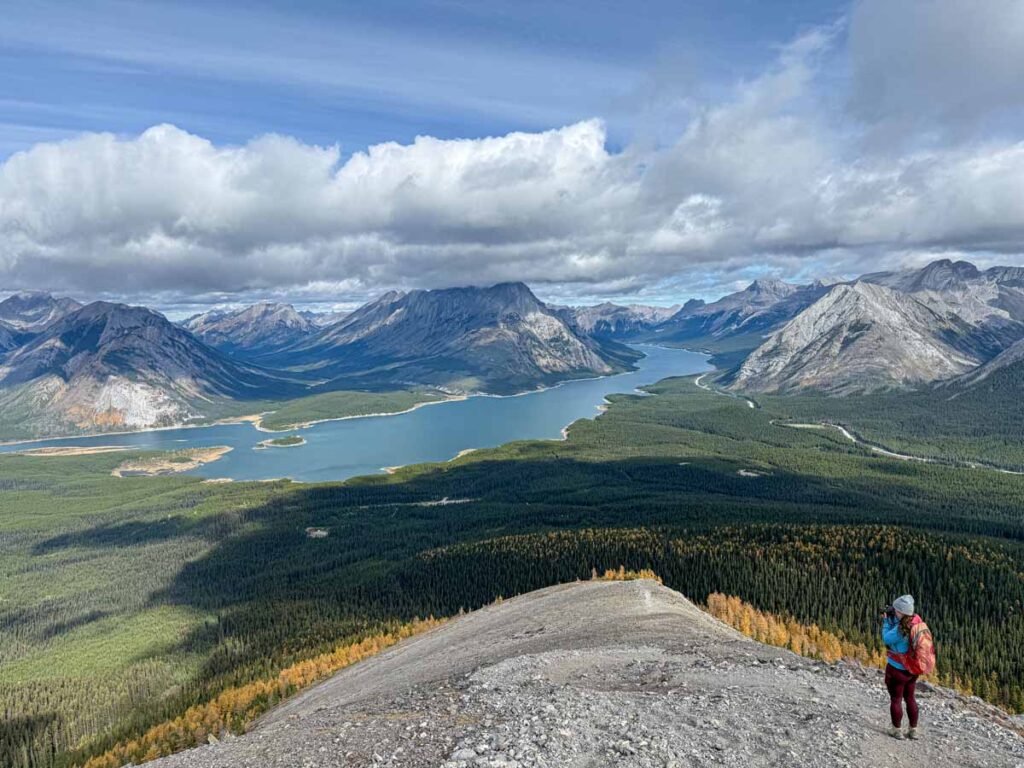
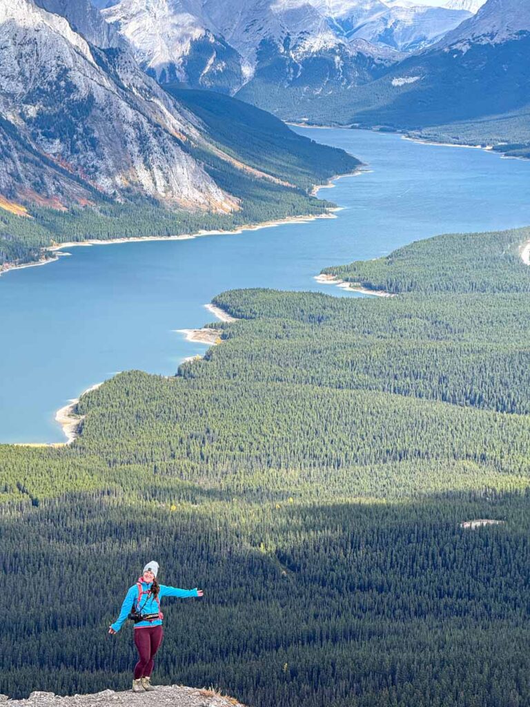
The descent from the weather station is a little tricky, with tight switchbacks and loose, slippery rock. At the 4.5 km (2.8 mile) mark, you reach the low point at the very top (and most southern part) of the Tent Ridge horseshoe. It’s hard not to keep stopping, as the views of the Spray Lakes just keep changing and are incredible from here. Plus, at this lower vantage point, The Fist is just that much more imposing overhead.
It’s about 500 m (1,600 feet) of straight uphill hiking from the pass to the highest point on the Tent Ridge trail. The climb isn’t technical in nature, but it is very steep. At one point, the tight “S” switchbacks become so tight, they are more like a wiggly “i”, so basically, straight uphill. At least it’s a great glute workout!
Finally, after 5 km (3.1 miles) of hiking the Tent Ridge Trail, you’ve reached the summit at an altitude of 2,525 m / 8,282 feet. After such a hard climb, take the time to stop and reward yourself for these hard-earned views!
Following the Western Ridge Above Shark Lake
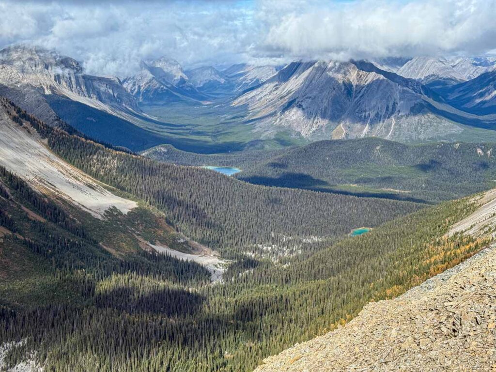
As you make your way north on the western horseshoe leg, on your left you’ll see a small lake with intensely green water; this is Shark Lake. We’ve snowshoed to Shark Lake in the winter, but I’d love to visit it in the summer to see the water colour up close!
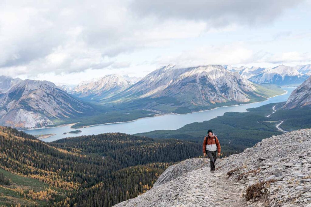
As the trail descends from the summit, it winds down through loose rock and scree. Given the loose footing, the trail gets uncomfortably close to the edge at times.
Around the 5.3 km (3.3 mile) mark, the trail meets up with a section of bowling ball sized rocks, covered in green lichen. We lose the trail here every single time we’ve hiked Tent Ridge. If you also find yourself looking for the trail, it’s probably below you on the left.
Once you are past the large rocks that always trick me, you can now see beyond Shark Lake to Watridge Lake and into the valley beyond. The number of mountain peaks you can see from the Tent Ridge hike is truly astounding!
Continuing Along the Long Western Side of Tent Ridge
By the 6 km (3.7 mile) mark, it feels like you should be reaching the end of the horseshoe shaped ridge, but the western leg is significantly longer than the eastern leg (which you started on). The hiking is slightly downhill here, but feels hard due to the uneven and loose rocks underfoot.
As you near the true end of the ridge section of the Tent Ridge hike, take a moment to look back at where you’ve come from. Take a look at the steep incline up the start of the ridge, and the many ups-and-downs along the way. It’s a really impressive hike and it’s fun to enjoy it from this vantage point.
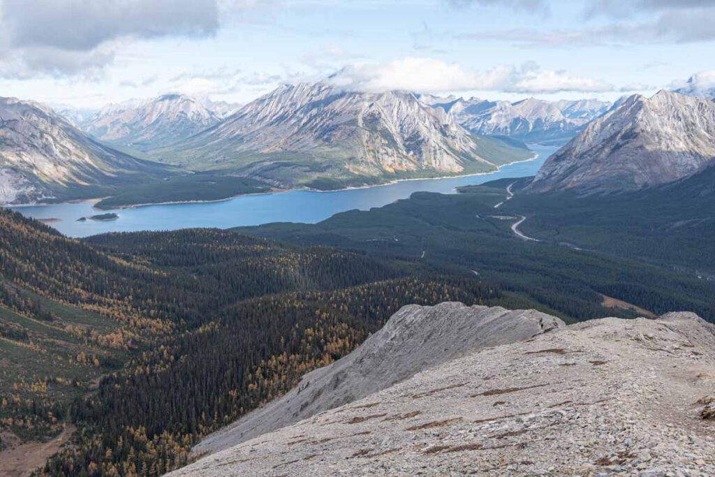
After 7 km (4.3 miles), you’ll reach the final hump of the Tent Ridge horseshoe. After a full day of enjoying epic views of the Spray Lake Reservoir, this is the best view yet. You can see nearly the entire length of the lake, with towering mountains up and down its shoreline. Yet another breathtaking sight, in a hike that is full of breathtaking sights!
Descending From Tent Ridge Back to the Valley
After taking many pictures, you’ll start to descend from the top of the ridge, back to the valley floor below. Again, watch your step carefully here as the descent is steep, along tight switchbacks on loose gravel. It’s easy to lose your footing here as both Celine and I did!
After 200 m (650 feet) of steep descent, the trail takes a sharp right-hand turn. Before you turn here though, make sure to continue straight a little bit to the viewpoint. This is the spot where everyone wants to take their Instagram photo, and it’s easy to understand why. So beautiful…
From here, the Tent Ridge Trail now runs along the side slope of the mountain, instead of straight down the ridge. The trail is heading towards the larch forest at the bottom. Once you reach the trees, it’s easy to trick yourself into thinking you’ve reached the bottom, but you still have a long way to go before you reach the bottom.
Finally, with only 0.8 km (0.5 miles) left in the hike, the Tent Ridge trail stops descending. Here the trail meets up with the trail to Shark Lake. From here to the parking lot, the trail is wide and reasonably flat; a nice way to end this epic hike on the Tent Ridge Trail.

Let me Help with Your Banff Itinerary?
We have a suite of Banff Travel Planning services that can take all the guesswork out of planning your trip! Book a 1 hour travel consultation or let me create a custom Banff Itinerary for you!
Directions to the Tent Ridge Horseshoe Trail
The Tent Ridge Horseshoe trailhead is in the Mount Shark area in Kananaskis Country. It’s approximately 2 hours and 10 minutes from downtown Calgary to Tent Ridge, or a 90 minute drive from the Banff townsite to Tent Ridge.
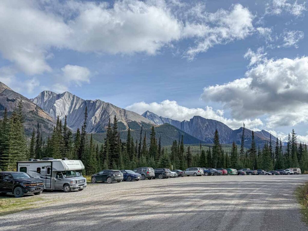
This is an enormously popular Kananaskis hike, and the existing parking lot is often filled to capacity, especially on weekends, holidays or anytime during larch season. Arrive early and avoid peak hours if possible.
Directions to the Tent Ridge Horseshoe Trailhead Parking Lot
A Kananaskis Conservation Pass is required if you park a vehicle in Kananaskis Country, including the Mount Shark / Tent Ridge area. Buy it before you arrive, since cell service is not typically available along the Smith-Dorrien Trail.
Tent Ridge Trail Map
There are plenty of hiking trails in and around the Tent Ridge Horseshoe Trail in the Mount Shark region of Kananaskis. Although the trail is reasonably well marked, it’s always a good idea to have a digital version of the trail map downloaded on your phone.
If you’d like a digital map of the hike along with the ability to track your stats (distance, elevation gain, etc.), I personally use and recommend the AllTrails hiking app. You won’t get any cell service in this area, so be sure to download the Tent Ridge Horseshoe Trail hiking map prior to leaving.

Banff App Pick
AllTrails is one of our most recommended apps for visiting Banff, and your trip is the perfect time to try AllTrails Plus. Start with the 7-day free trial to download maps, save hikes, and use premium features before heading into the mountains.
Tent Ridge Horseshoe Hiking Safety Tips
Before we get into Tent Ridge safety tips, it’s important to be honest about the nature of this hike. If you feel like you need a detailed list of safety tips to feel comfortable attempting Tent Ridge, this may not be the right trail for you.
Tent Ridge is best for hikers who already have experience on steep, loose, exposed mountain terrain and are confident making good decisions without relying on step-by-step guidance.
Before hiking Tent Ridge, we recommend checking the latest Alberta Parks Kananaskis trail reports, especially if you are hiking early or late in the season. Alberta Parks does not always list Tent Ridge as its own individual trail report, but regional updates for Kananaskis can help you understand current snow, mud, wildlife, or closure concerns before committing to this exposed ridge hike.
Tent Ridge Trail Logistics
Despite its immense popularity, there are no toilets in the Tent Ridge parking lot. If anyone needs to go, continue to the main Mt. Shark Day Use Area / Watridge Lake trailhead, where Alberta Parks lists pit/vault toilets.
Likewise, there are no drinking water facilities at the Tent Ridge trailhead. Due to the length and difficulty of this Kananaskis hike, ensure you fill your reusable water bottles or hydration packs before you leave home.
On-leash dogs are allowed on the Tent Ridge hike, but we recommend leaving your dog at home. The scramble sections will not be fun for your furry friend and bringing your dog may endanger you or other hikers.
What to Bring for Hiking Tent Ridge
Again, if you are capable of hiking the Tent Ridge Horseshoe Trail, you probably don’t need my list of essential hiking gear.
That said, there’s one thing I’d like to suggest you bring on this hike. There is more trailside toilet paper on the Tent Ridge trail than I’ve seen anywhere else in the Canadian Rockies. It’s become a problem, so please bring a small garbage bag to pack out your toilet paper
Support Human Created Content

Hi, we’re Dan & Celine Brewer, locals from just outside Banff National Park. Every article, itinerary, and recommendation we share is rooted in our real experiences and love for this place. If you’ve found our content helpful, please consider supporting us:
- Make a small donation: Your support directly fuels our work and keeps our stories genuine.
- Purchase a guide or itinerary: Essential tools that help plan your trip and support local creators at the same time.
- Book lodging or tours through our affiliate links: You pay the same price, but we earn a small commission that helps us keep producing content.
Thank you for valuing authentic, human-created content. Your support allows us to help even more Banff travellers!

Dan Brewer, a life-long Alberta resident, calls Canmore home along with his wife and two kids. He is the co-owner of Travel Banff Canada, where he gets to share his passion for the Canadian Rocky Mountains. Dan, along with his family, love being outdoors doing one of the many activities they enjoy in the mountains: hiking, mountain biking, paddleboarding, skiing, snowshoeing and cross-country skiing.
When he's not in Canmore enjoying one of his favourite local hikes, you can find him hopping on a plane to explore a new country with his family or working on one of their other two travel sites: Family Can Travel and Baby Can Travel.